A Soil Infiltration Cookbook: How Deep Does Your Water Go?

Street Flooding Due to Failing Infiltration Systems – Yakima, Washington (Source: Aspect Consulting)

The Pacific Northwest recognized early on the negative effects of urbanization on receiving waters and has been a leader in the stormwater management field for decades. This was initially driven by concerns about the impacts of urban runoff on threatened and endangered species in the Puget Sound area, and later reinforced by the National Pollutant Discharge Elimination System (NPDES) permitting program.

More recently, a study led by the University of Washington solved the mystery of why Coho salmon are dying in urban streams before spawning. As many suspected, stormwater runoff is the culprit. It was found that runoff from high traffic areas contains a tire-related chemical that is toxic to Coho.

As the science of stormwater management continues to progress, practitioners must learn about and apply the latest techniques, including the use of stormwater infiltration. While infiltration is not really a new concept, widespread infiltration design is new for some areas and some water quality designers. When infiltration systems fail, the consequences can range from increased pollutant loading and erosion in streams to flooded roads, businesses, and homes. 

Infiltration Design For Cleaner Water and Better Habitat

Many agencies operate stormwater programs under NPDES Municipal Separate Storm Sewer System Permits (MS4 Permits). MS4 Permits require development projects within the permittee’s jurisdiction to include permanent Best Management Practices (BMPs) to reduce stormwater pollution and flow-related problems. Permanent BMPs typically include detention vaults, filters, and bioretention basins.

Over the last decade, MS4 Permits have started requiring the use of infiltration BMPs to mitigate the hydrologic and water quality impacts of development. From a surface water perspective, infiltrated runoff does not cause stream erosion, has no pollutant loading, and helps recharge groundwater.

Using Infiltration to Reduce Hydrologic and Water Quality Impacts (Source: Aspect Consulting)

Lessons Learned from the Track Record of Filtration and Infiltration

Much like the early application of other stormwater BMPs, some designers don’t have a technical background in infiltration. Numerical models, simplifying assumptions, and step-by-step procedures make applying infiltration feasible for generalists, but there are some key issues to consider.

Accurately Estimating Infiltration Rates. The starting point for designing an infiltration BMP is determining the infiltration rate your BMP is expected to have. Allowable methods have changed over the years, with some agencies requiring in-situ infiltration testing for all infiltration BMPs, and some allowing “grain size methods” to estimate rates in certain cases. It’s recommended to only use grain size methods for screening purposes when soils meet all criteria for application of the equation being used.

Reliance on grain size method results can backfire, which is why in-situ infiltration testing must be done to support the design process, with knowledgeable analysis of testing results. The number of infiltration tests should scale with the size, complexity, and soil heterogeneity of the project site. Thoughtful testing and analysis methods can also indicate if groundwater was mounding during the test, and whether a formal mounding analysis is needed.

Once correction (safety) factors are applied, there are generally two ways an infiltration rate is used to help model and design infiltration BMPs: (a) assume the infiltration rate is constant during BMP filling and emptying; or (b) assume the infiltration rate varies (typically linearly) with water depth (pressure head) above the infiltration surface. Knowing how the infiltration BMP will be sized is important when analyzing test data because the resulting constant infiltration rate will not necessarily be the same value as the variable rate.

Extreme plugging/sediment loading to a proprietary stormwater filter (Source: Oregon Department of Transportation, Operation and Maintenance Manual, DFI No.: D00183, 2011)

Plan to Manage Plugging. Infiltration BMPs are susceptible to the same plugging by stormwater sediments and biofouling that stormwater filters are. Stormwater filters plug up and infiltrating into soil is like infiltrating into a filter. Therefore, pre-treatment to remove sediment is necessary to prolong the life of infiltration BMPs.

Plugging of the infiltration surface is the main reason safety factors are used when sizing infiltration BMPs. Stormwater manuals often prescribe safety factors, but the safety factor really should scale based on the soil being infiltrated into.

For instance, when infiltrating slowly into a fine soil with a permeability not much higher than stormwater sediment, reducing the measured rate by a factor of 2-4 is acceptable. But when infiltrating into coarser soil with a permeability much greater than stormwater sediment, a larger safety factor is warranted (some jurisdictions do set a maximum design infiltration rate). The level of treatment for sediment removal prior to infiltration should affect the safety factor too.

Check and Address Groundwater Mounding. Infiltrating runoff sometimes causes groundwater mounding. As mounding increases, it can reduce the infiltration rate, cause seepage problems, and raise regulatory compliance concerns. We recommend monitoring groundwater during infiltration testing to see if it rises in response to the test. If so, the data can be used to help calibrate a mounding model. In cases where mounding is an issue, a formal analysis and modeling (such as USGS’s MODFLOW) of the receptor soil/aquifer combination should be done and infiltration BMP flowrates and spacing fine-tuned to avoid mounding problems.

Increasing Focus on Deep Infiltration to Meet Low Impact Development Goals

The use of “deep” infiltration to meet project Low Impact Development and flow control requirements has been increasing, particularly where surface soils have low permeability but overlie an unsaturated higher permeability soil. It can be feasible to bore through the surface soil and install an infiltration well in a more permeable receptor soil. Stormwater runoff is routed into the well and infiltrated into the receptor soil.

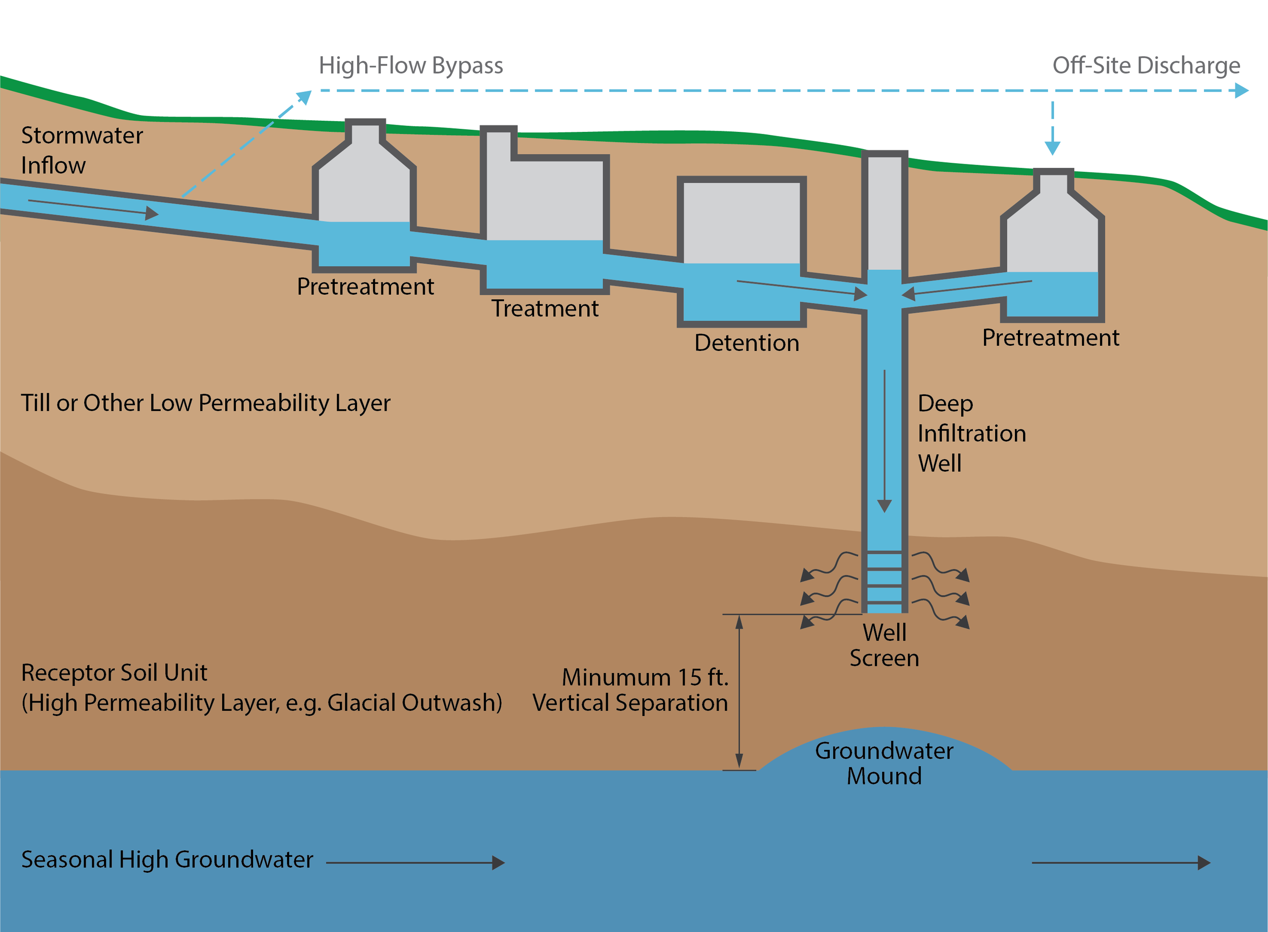
Simplified Deep Infiltration Schematic (Source: Aspect Consulting)

The concept of deep infiltration is straight forward but a system that reliably functions for decades requires some careful thought. To prevent plugging, it’s critical to keep sediment out of deep infiltration wells. However, normally some runoff is allowed to bypass treatment BMPs during large storms. Directing untreated flow into infiltration wells will reduce their service life. Another consideration is whether advance BMPs can be a source of initial sediment loading including: Is that drain rock really clean? Should I specify on-site washing of drain rock? Will my bioretention mix initially leach sediment? Should I flush the system before connecting to infiltration BMPs?

We recommend designing deep infiltration wells to:

  • Include treatment to remove sediment for
    all flows to the well

  • Control the rate of flow into the well to
    the design rate

  • Reserve head to allow water levels to rise to counteract plugging

  • Prevent baseflows from entering infiltration wells

  • Ensure the system drains down in a
    reasonable time

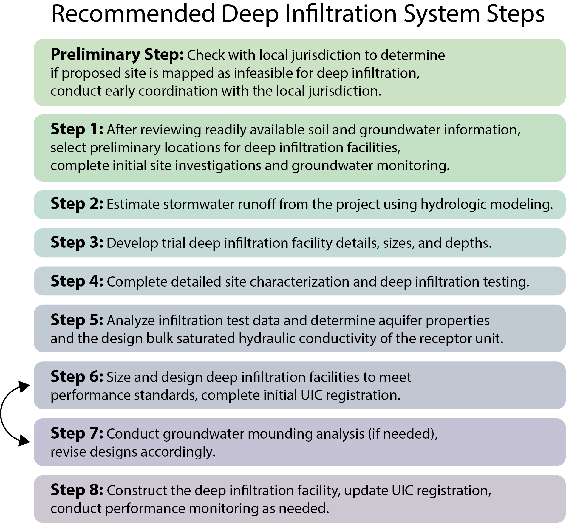
Using the ‘Infiltration Cookbook’: Infiltration System SOPs

Consistent and successful stormwater infiltration requires clear and comprehensive guidance for planning through construction. As part of the team preparing an updated LID Manual for the Port of Seattle’s Seattle-Tacoma International Airport (STIA), Aspect developed Standard Operating Procedures (SOPs) for shallow and deep infiltration systems. The detailed SOPs for the Port of Seattle— both for shallow and deep infiltration — are publicly available and are a good example of a successful ‘cookbook’ for creating sustainable infiltration design.

SOPs provide guidance for planning, testing, analysis, design, and construction of infiltration facilities. Recommended SOP steps for deep infiltration are shown here:

For more information about soil infiltration best practices for water quality and stormwater issues, contact John Knutson.

An edited version of this article appeared in the February 2022 version of Stormwater Magazine.

Meet Dawn Chapel

Aspect recently welcomed Senior Hydrogeologist Dawn Chapel, LHG, to our Seattle office. Here are Five Questions we asked to get to know her better.

Dawn out hiking east of the Cascades.

Dawn out hiking east of the Cascades.

1. Where are you from? If you’re not from the Pacific Northwest, what brought you here?

My roots have been the Pacific Northwest for the past 18 years. I was actually born and raised in Los Angeles, visiting my father in Eugene, Oregon, every summer and climbing the mountains of the Pacific Northwest. I always wanted to move to the Pacific Northwest, but I took a long path to get here. My family moved to Massachusetts in my 20s, where I majored in geology at Smith College. I loved New England, the small towns, and the fall colors. I then lived in Madison, Wisconsin, earning my master’s degree in geology before finding my path here to Seattle to begin my career in consulting. I think it was the summer I took off as a park ranger in Colorado that made me realize I needed to get back to the mountains of the West.

2. What inspired you to pursue hydrogeology? What made you curious about it?

I grew up exploring the mountains and deserts of Southern California. I always loved rocks and reading the story in the landscape around me. I have collected a large rock collection over the years from various places – as most geologists do. I was also always aware of the importance of water living in Southern California – Save Mono Lake! I really like the applied aspect of hydrogeology. Merging the fields of geology with water resources was a way to apply my love of earth sciences while working with other scientist and engineers to manage an important resource.

3. What do you like best about your area of expertise? What excites you and keeps you motivated?

I enjoy working with a team investigating and solving problems and the satisfaction of finding a solution. I’m always eager to learn new skills and provide mentorship to others and build close relationships with my co-workers and clients.

4. What do you like to do when you aren’t working?

I enjoy hanging out with my dog, three cats, and wife at home. We seem to always be working on a new house project. I also love to get outdoors – hiking, mountain biking, backpacking, scrambling, skiing, etc. I enjoy playing guitar, reading, and getting together with friends and family. We also regularly go to our Tiny House in Twisp where my dad lives.

5. What five people would be your dream dinner party guests?

John Lennon, Amelia Earhart, Mary Oliver, Thich Nhat Hanh, and Winnie the Pooh. I believe that would be a fun gathering with a very lively discussion.

Kicking Off a Yearlong Look into Kitsap Peninsula’s Groundwater Supply

Over the next year, one 900-foot-deep well in Silverdale, Washington will play a key role to help forecast future water needs for Kitsap County communities. A unique year-long pumping test led by Kitsap PUD, with support from Aspect, will produce a treasure trove of water data to evaluate groundwater supply, pumping effects on other groundwater sources, and impacts to streamflows. The well will be pumped continuously at a rate of 1,000 gallons per minute and the effects of the high pumping rate will be measured across a 50+ well network. While pumping tests are a common tool in a hydrogeologist’s tool kit, the year-long length of this test is rare. “Hydrogeologist’s dream of doing this kind of aquifer test,” said Joel Purdy of Kitsap PUD.

Read more about this exciting project in this article from the Kitsap Sun.


Clean, Cold Water at the Entiat Hatchery Means Healthy Fish

Earlier this spring, fisheries managers made a startling announcement: there would be no recreational salmon fishing in the Columbia River or its tributaries in 2019. Simply put, there weren’t enough fish to go around.

Aspect Angler Jordan Sanford with a catch on the Enitat

Then, the unexpected happened. Day by day and fish by fish, the number of salmon ascending the Columbia River grew. By early July, increasing counts of summer-run Chinook returning to the upper Columbia made it clear that broodstock goals for regional hatchery programs would indeed be met. On July 11, the Washington State Department of Fish and Wildlife shared some exciting news: local anglers would have a salmon-fishing season after all.

As showcased in a recent article in the Wenatchee World, one reason for this year’s fishing season is strong returns of adult Chinook to the Entiat National Fish Hatchery. In 2014, Aspect hydrogeologists assessed the hatchery’s water supplies and rights, and the condition of their infrastructure. Aspect’s recommendations helped improve the hatchery’s access to a reliable supply of clean, cold water—one of many factors that contribute to healthy juvenile fish and hard-fighting adults at the end of an angler’s line.

Reducing Washington State Drought Impacts in the Okanogan River Basin

In both the northern reaches, high desert region, and even the Olympic Peninsula—literally one of the wettest places in the lower 48 states historically—summer 2019 is a serious drought year in Washington State. Earlier this spring, the governor declared a drought emergency, which was able to unlock emergency relief options and funding for 27 watersheds across the entire state. In the Methow, Okanogan, and upper Yakima River watersheds, it’s particularly bad. Based on current forecasting, the Okanogan is expected to be at 58 percent of normal, and curtailment notification letters have already been sent to local water users. However, this drastic forecast has prompted forward thinking. 

In partnership with the Washington State Department of Ecology (Ecology), the Oroville-Tonasket Irrigation District (OTID) has developed a “water bank” in the Okanogan River basin to help regional water users impacted by the drought. The water bank will be used to support instream flows and to assist “junior” water users during periods of curtailment. OTID is seeding the bank with two of its senior water rights. In 2018, Ecology, with assistance from Aspect, certified these water rights through the state’s Certified Water Right Examiner process. 

Ecology is working to complete the required permitting to place the water rights in the state’s Trust Water Right Program (TWRP) to create the water bank (read more about water banks on Ecology’s website). This water bank will be seeded with about 7,500 acre feet of water, which will be made available for drought relief. From this bank, eligible water users can “withdraw” water for both irrigation and municipal or domestic uses.

 More information can be found at the following website:

https://www.aspectconsulting.com/otidwaterbank

Wet weather season: When the levees go to work

November is historically the wettest month of the year in western Washington. The seemingly constant mist of precipitation punctuated by storms that dump inches of rain in short amounts of time sends water levels in area rivers rising. The risk of flooding presents a critical need to protect nearby homes, businesses, and habitat. Levees a play a key role in that protection.

In the old days of flood control, a levee was typically little more than a pile of dirt. These days, they’re still dirt, but have evolved into a highly engineered, specifically designed mass, often made from less permeable soil (like clay) and designed wider at the base and narrower at the top. Levees are especially critical in floodplain areas to maintain healthy fish and riparian habitats, and of course near neighborhoods and businesses that would be vulnerable should a river top its banks.

While western Washington’s levees are working to protect their surrounding areas, Aspect is hard at work supporting several levee improvement projects in King County and beyond. Our services for recent and ongoing projects include:

Lower Russel Road Levee Setback, Kent, WA

Lower Russel Road Levee Setback, Kent, WA
Map from King County's Project Website

Lead geotechnical engineer and hydrogeologic support for Lower Russell Road Levee Setback, which is improving 1.4 miles of the flood control system along the Green River in Kent. Once completed, the project will provide greater flood protection and water conveyance capacity while improving both riparian habitat and recreational opportunities. This project is nearing the 60 percent design stage of completion, and is anticipated to be constructed by 2020. More project information and pictures can be found on King County’s project page

South Unit Shillapoo and Buckmire Slough Restoration Design, Vancouver, WA

South Unit Shillapoo and Buckmire Slough Restoration Design, Vancouver, WA
Map from the Washington State Department of Fish and Wildlife’s project website

Geotechnical engineering and hydrogeologic efforts for the South Unit Shillapoo and Buckmire Slough Restoration Design, along the Columbia River in Vancouver, Washington. The project will improve hydrologic access to approximately 540 acres of intertidal, freshwater slough and wetland habitat. Our work first includes subsurface explorations and geotechnical design for breaching the existing levee (to clear room for the new levee); constructing three WSDOT bridges along State Route 501; flood control levee construction; roadway raises to meet 100-year flood elevations; and construction of up to 14 interior water control structures in the wetland system. You can read more about the project on the Washington Department of Fish & Wildlife’s website

Countyline Levee Setback, Pacific, WA

Environmental and geotechnical support for the Countyline Levee Setback project along the White River near Pacific, just north of the border with Pierce County. When contaminated materials were encountered during construction of the Levee Setback project, our environmental team advised the County on whether the material posed a risk to the project if left in-place, while also determining proper disposal methods. Our geotechnical engineers conducted a targeted, cost-effective investigation to study flooding during high flows and collected data to inform the levee setback design. The project was finished this fall, just in time for late October rains, and now protects 121 acres of floodplain. See an aerial video of the project below

Pacific Right Bank Project, Pacific, WA

Pacific Right Bank Project, Pacific, WA
Map from King County’s project website

In late November, Aspect will provide both geotechnical and environmental services on the Pacific Right levee setback, along the opposite site of the White River from the Countyline Levee. The project will create a setback levee between the BNSF Railway and Government Canal to significantly reduce the potential for river flooding of adjacent neighborhoods. Learn more about the project on King County’s project website.