Spotlight on Former Orchard Land Cleanup in Central Washington for New Housing

In Washington state’s agricultural hubs – Wenatchee, Yakima, and Chelan – former orchard land is being redeveloped to meet housing demands. Aspect has worked on several projects that are safely turning these brownfield sites into new housing for residents.  

As the Washington State Department of Ecology recently detailed, former orchard lands have a history of pesticide use, and the type of pesticides used has changed over time. Orchards that were active between 1900 and 1950 generally used lead arsenate, which left residual concentrations of both lead and arsenic in near-surface soil at concentrations above Ecology’s cleanup levels.

Example of former orchard land in East Wenatchee, where new housing now sits.

Snapshot of Former Orchard Land and Cleanup Process

Ecology has classified these former orchards with potential lead arsenate contamination and included them in their publically available ‘Dirt Alert’ program (based on historical aerial photo interpretation and other methods). As shown in the image below, orchard lands are generally concentrated in the Columbia, Yakima, Okanogan, and Wenatchee river basins throughout central Washington.

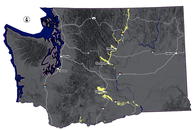
Using Ecology’s publicly available Dirt Alert mapping, see land (yellow on map) that Ecology delineated as orchard during the lead arsenic era: 1900-1950

Project Spotlight: Cleanup and 20 New Residential Homes near Chelan, WA

Aspect recently supported Chelan County to cleanly ‘cap’ the soil at a former orchard residential redevelopment in Manson near Lake Chelan for 20 new homes so it would protect human health and the environment. Chelan County Natural Resources Department used an Ecology grant to evaluate the costs associated with implementation of a Model Remedy (that is, a clean cap remedy) for this ‘trial implementation’. Aspect supported Chelan County by:

  • Sourcing and analytically testing clean soil cap sources

  • Sourcing and calculating soil amendment (compost) requirements for lawn support

  • Construction sequence and contractor coordination

  • Cost tracking

The trial found that the cost of implementing the clean soil cap model remedy amounted to approximately $5,000 per parcel.

Model Remedies Cleanup for Agricultural Owners and Developers

Model Remedies can guide property owners, developers, and consultants to clean up these lead arsenate properties efficiently and protect the community. Contamination is often limited to just the topsoil layer, thus reducing the complexity of cleanup. There are a few routes to cleanup:

  • Excavation and off-Site disposal is a conventional clean-up method that in most cases is too costly for a residential redevelopment.

  • Capping is a model remedy in which the contaminated soil remains on site and is “capped” with asphalt, building foundations, and delineated landscaping beds and is generally the most cost-effective model remedy.

  • Mixing is a solution where the soil column is mixed until contaminant concentrations throughout the soil layer are all below cleanup levels. A mixing model remedy could be applicable when contamination is limited to a very shallow depth.

Capping is the most commonly used cleanup method in the Model Remedy process. Capping keeps residential communities safe by providing a physical barrier (such as asphalt or colored demarcation fabric beneath the topsoil) between residents and the contaminated soil. Lead arsenate is generally contained within the near-surface soil, so there is no exposure risk related to drinking water or using groundwater. Also, because metals do not vaporize, there is not a threat of vapor intrusion into structures.

Contact Aspect’s Breeyn Greer and Adam Griffin for more information about the cleanup process for orchard redevelopment.

Jamestown S’Klallam Tribe’s Rivers Edge Levee Setback Project Wins ASCE LOCEA Award

The Seattle Section of the American Society of Civil Engineers (ASCE) honored the Jamestown S’Klallam Tribe’s (JST) Rivers Edge Levee Setback project with its 2022 Local Outstanding Civil Engineering Achievement Award (LOCEA) in the Geotechnical category.

The project replaced an aging, constricting levee on the Lower Dungeness River near Sequim with a new levee setback designed to meet modern flood protection standards and aligned to restore the area’s natural floodplain and salmon habitat. Work completed on a compressed, whirlwind schedule. JST acquired the land and started preliminary design in mid-2020, and by September 2021, they’d completed final design, successful navigation of a complex series of permit applications and design reviews, and substantial construction—a monumental feat in just 14 months.

The new levee was constructed in part with gravel from a nearby quarry pit, limiting the cost, time, and environmental impact of importing materials to the site. The project was done in tandem with an adjacent similar levee project by Clallam County, and together they will open up 143 acres of reclaimed floodplain and habitat. You can learn more about the Rivers Edge project in our previous blog post.

Aspect led geotechnical engineering design and construction of the levee as a subconsultant to Pat McCullough and his firm Engineering Services Association (ESA), alongside WEST Consultants for hydrology and hydraulics.

Aspect’s Project Manager and Lead Geotechnical Engineer Andrew Holmson and Project Geotechnical Engineer Mari Otto gave a short presentation on the project during the LOCEA virtual awards ceremony on Wednesday, March 9.  

Other LOCEA Winning Projects

Aspect was also on the winning teams for two projects as geotechnical subconsultants to our frequent teaming partner Osborn Consulting:

  • The City of Kenmore’s new boathouse on the Sammamish River won in the Small Projects and Non-Construction Studies category. We provided foundation redesign support and services during construction of the two-story prefab metal building that is the new home for the Kenmore Community Rowing Club and Northshore School District rowing programs.

  • The City of Sammamish’s Ebright Creek Fish Passage Culvert Replacement was honored in the Water Resources category. Aspect led the geotechnical evaluation for design and construction of two new 30-inch-diameter culverts along busy arterial East Lake Sammamish Parkway. Replacing the outdated culvert was a priority for the City of Sammamish to enhance fish passage and habitat for kokanee salmon. Construction was completed in fall 2021, and the City has already seen an increase in returning kokanee and other fish species passing through this stretch of the creek.

This year’s other LOCEA winners honored during the ceremony were:

  • Climate Pledge Arena Renovation (Thornton Tomasetti) – Structures

  • Northgate Link Extension (MJA) – Transportation and Development

  • 2021 Airfield Pavement Replacement + Infrastructure Upgrade Project (HNTB) – Transportation and Development

  • Seattle-Tacoma International Airport North Satellite Modernization (AECOM) – Transportation and Development

The Path to Professional License: Isabellah von Trapp, LG

In the science and engineering industry, seeing a “PE”, “LG”, “PMP”, or other initials behind someone’s name shows that person went through years of work experience that culminated in a substantial test to confirm the right to practice their area of technical expertise. A professional license is a proof statement that communicates that the people charged with designing roads and buildings; solving water supply challenges; cleaning up contaminated soil and water; and successfully managing project quality are qualified and ethically accountable professionals. Many go through this licensing journey but few outside that group know what the process is really like.

We’re telling those stories here. Aspect’s professionals are writing a series of articles that capture the trials and successes of studying for and receiving these career-defining milestones.

Isabellah von Trapp, Licensed Geologist (LG)

Test taken: October 2021

Results given: November 2021

Isabellah at Mt. Rainier demonstrating how she felt when she received her LG exam results.

Where did you start with your test prep?

I got out some construction paper and my favorite markers and drew a big, beautiful geologic time scale and geologic diagrams (e.g., fault blocks, Bowen’s Reaction Series, etc.). I hung them on the wall adjacent to my desk so it would be a constant reminder to study. Helpful? Not really. But it was a nice and fun way to ease into reviewing what initially felt like a very daunting amount of material.

What were your study tactics?

Practice tests, reviewing the study guide, flipping through flash cards, desperately seeking ASBOG advice on Reddit (r/geologycareers for curious minds), etc.

Walk us through the Big Test Day…

I woke up around 8 am. The test didn’t begin until early afternoon, so I tried to sleep in as much as my body would let me. Despite the nerves and not feeling hungry at all, I forced myself to eat something. I opted for oatmeal, a clementine, and some coffee. I put on my favorite jeans (for style) and favorite flannel (for comfort). Perhaps unsurprisingly for a geology exam, the exam room, as I would later find out, was full of people in very similar outfits.

Having an intense fear of being late, I left Seattle around 9:30 am for a 1pm exam in Olympia. On the drive down I listed to all my favorite music. Upon arrival, my extra time – given the dramatically early arrival – was spent reviewing the study guide in my car. I don’t think I learned anything new at that point but it eased my mind to have one last look at things.

There was a lot of nervous energy in the exam room leading up to the test. I remember the first page of questions being fairly easy, which inspired initial confidence, but they seemingly got harder as the exam progressed. Afterwards, I genuinely felt pretty bad about the way it went. I drove home semi-deflated but happy to be done in the interim. Later that evening I met my friends at a cabin on a lake for the weekend. It was nice to get my mind off the test.

How did you feel when you got the results?

Honestly, I was shocked. One of my old college classmates took the exam at the same time. He called me one Thursday night (after I had just landed in New Orleans for a short, extended weekend vacation) to see how I did as he had just received his passing results. Anxious, I checked my email. Nothing! I refreshed my email approximately every 10 minutes for a few hours but didn’t hear anything that evening. At this point, I assumed I failed and would be a recipient of the “We regret to inform you” email the next day. Much to my delight, I got a congratulatory email and a digital copy of my newly minted license the next day. A sunny Friday in New Orleans was the perfect time and place to receive this news. You can bet I took myself out for a beer (or two) after that!

What was the best piece(s) of advice you got from others who’d done this before?

  • Life does in fact go on if you don’t pass the exam on the first try.

  • Even if you do pass, you will probably feel like you didn’t afterwards so there’s no sense in stressing during the approximate 45-day period it takes to get your results. Think “ignorance is bliss” purgatory.

What should a person gearing up to do this know about the mental, physical, and social challenges of test prep?

Depending on how you study/absorb material, you probably won’t have much of a life for a month or two leading up to the test. However, you probably will not set yourself up for success if your mental batteries are drained at the expense of your physical and social health. I think it’s critically important to give yourself a break. About 3 weeks before my exam, I skipped a weekend study session to go backpacking through the Enchantments with my friends. This was probably the best thing I could have done.  

Any parting advice for those getting ready to embark on this journey?

The LG exam is offered twice per year – once in March and again in October. If possible, try to take the exam in March so you can spend the rainy winter months inside studying instead of the coveted, sunny, August/September days. Also, have a treat on deck to enjoy immediately after the exam is finished. I did not anticipate how hungry I would be afterwards. Unfortunately, I did not heed either piece of my own advice in this instance, but that is okay. Hindsight is indeed 2020.

A Soil Infiltration Cookbook: How Deep Does Your Water Go?

Street Flooding Due to Failing Infiltration Systems – Yakima, Washington (Source: Aspect Consulting)

The Pacific Northwest recognized early on the negative effects of urbanization on receiving waters and has been a leader in the stormwater management field for decades. This was initially driven by concerns about the impacts of urban runoff on threatened and endangered species in the Puget Sound area, and later reinforced by the National Pollutant Discharge Elimination System (NPDES) permitting program.

More recently, a study led by the University of Washington solved the mystery of why Coho salmon are dying in urban streams before spawning. As many suspected, stormwater runoff is the culprit. It was found that runoff from high traffic areas contains a tire-related chemical that is toxic to Coho.

As the science of stormwater management continues to progress, practitioners must learn about and apply the latest techniques, including the use of stormwater infiltration. While infiltration is not really a new concept, widespread infiltration design is new for some areas and some water quality designers. When infiltration systems fail, the consequences can range from increased pollutant loading and erosion in streams to flooded roads, businesses, and homes. 

Infiltration Design For Cleaner Water and Better Habitat

Many agencies operate stormwater programs under NPDES Municipal Separate Storm Sewer System Permits (MS4 Permits). MS4 Permits require development projects within the permittee’s jurisdiction to include permanent Best Management Practices (BMPs) to reduce stormwater pollution and flow-related problems. Permanent BMPs typically include detention vaults, filters, and bioretention basins.

Over the last decade, MS4 Permits have started requiring the use of infiltration BMPs to mitigate the hydrologic and water quality impacts of development. From a surface water perspective, infiltrated runoff does not cause stream erosion, has no pollutant loading, and helps recharge groundwater.

Using Infiltration to Reduce Hydrologic and Water Quality Impacts (Source: Aspect Consulting)

Lessons Learned from the Track Record of Filtration and Infiltration

Much like the early application of other stormwater BMPs, some designers don’t have a technical background in infiltration. Numerical models, simplifying assumptions, and step-by-step procedures make applying infiltration feasible for generalists, but there are some key issues to consider.

Accurately Estimating Infiltration Rates. The starting point for designing an infiltration BMP is determining the infiltration rate your BMP is expected to have. Allowable methods have changed over the years, with some agencies requiring in-situ infiltration testing for all infiltration BMPs, and some allowing “grain size methods” to estimate rates in certain cases. It’s recommended to only use grain size methods for screening purposes when soils meet all criteria for application of the equation being used.

Reliance on grain size method results can backfire, which is why in-situ infiltration testing must be done to support the design process, with knowledgeable analysis of testing results. The number of infiltration tests should scale with the size, complexity, and soil heterogeneity of the project site. Thoughtful testing and analysis methods can also indicate if groundwater was mounding during the test, and whether a formal mounding analysis is needed.

Once correction (safety) factors are applied, there are generally two ways an infiltration rate is used to help model and design infiltration BMPs: (a) assume the infiltration rate is constant during BMP filling and emptying; or (b) assume the infiltration rate varies (typically linearly) with water depth (pressure head) above the infiltration surface. Knowing how the infiltration BMP will be sized is important when analyzing test data because the resulting constant infiltration rate will not necessarily be the same value as the variable rate.

Extreme plugging/sediment loading to a proprietary stormwater filter (Source: Oregon Department of Transportation, Operation and Maintenance Manual, DFI No.: D00183, 2011)

Plan to Manage Plugging. Infiltration BMPs are susceptible to the same plugging by stormwater sediments and biofouling that stormwater filters are. Stormwater filters plug up and infiltrating into soil is like infiltrating into a filter. Therefore, pre-treatment to remove sediment is necessary to prolong the life of infiltration BMPs.

Plugging of the infiltration surface is the main reason safety factors are used when sizing infiltration BMPs. Stormwater manuals often prescribe safety factors, but the safety factor really should scale based on the soil being infiltrated into.

For instance, when infiltrating slowly into a fine soil with a permeability not much higher than stormwater sediment, reducing the measured rate by a factor of 2-4 is acceptable. But when infiltrating into coarser soil with a permeability much greater than stormwater sediment, a larger safety factor is warranted (some jurisdictions do set a maximum design infiltration rate). The level of treatment for sediment removal prior to infiltration should affect the safety factor too.

Check and Address Groundwater Mounding. Infiltrating runoff sometimes causes groundwater mounding. As mounding increases, it can reduce the infiltration rate, cause seepage problems, and raise regulatory compliance concerns. We recommend monitoring groundwater during infiltration testing to see if it rises in response to the test. If so, the data can be used to help calibrate a mounding model. In cases where mounding is an issue, a formal analysis and modeling (such as USGS’s MODFLOW) of the receptor soil/aquifer combination should be done and infiltration BMP flowrates and spacing fine-tuned to avoid mounding problems.

Increasing Focus on Deep Infiltration to Meet Low Impact Development Goals

The use of “deep” infiltration to meet project Low Impact Development and flow control requirements has been increasing, particularly where surface soils have low permeability but overlie an unsaturated higher permeability soil. It can be feasible to bore through the surface soil and install an infiltration well in a more permeable receptor soil. Stormwater runoff is routed into the well and infiltrated into the receptor soil.

Simplified Deep Infiltration Schematic (Source: Aspect Consulting)

The concept of deep infiltration is straight forward but a system that reliably functions for decades requires some careful thought. To prevent plugging, it’s critical to keep sediment out of deep infiltration wells. However, normally some runoff is allowed to bypass treatment BMPs during large storms. Directing untreated flow into infiltration wells will reduce their service life. Another consideration is whether advance BMPs can be a source of initial sediment loading including: Is that drain rock really clean? Should I specify on-site washing of drain rock? Will my bioretention mix initially leach sediment? Should I flush the system before connecting to infiltration BMPs?

We recommend designing deep infiltration wells to:

  • Include treatment to remove sediment for
    all flows to the well

  • Control the rate of flow into the well to
    the design rate

  • Reserve head to allow water levels to rise to counteract plugging

  • Prevent baseflows from entering infiltration wells

  • Ensure the system drains down in a
    reasonable time

Using the ‘Infiltration Cookbook’: Infiltration System SOPs

Consistent and successful stormwater infiltration requires clear and comprehensive guidance for planning through construction. As part of the team preparing an updated LID Manual for the Port of Seattle’s Seattle-Tacoma International Airport (STIA), Aspect developed Standard Operating Procedures (SOPs) for shallow and deep infiltration systems. The detailed SOPs for the Port of Seattle— both for shallow and deep infiltration — are publicly available and are a good example of a successful ‘cookbook’ for creating sustainable infiltration design.

SOPs provide guidance for planning, testing, analysis, design, and construction of infiltration facilities. Recommended SOP steps for deep infiltration are shown here:

For more information about soil infiltration best practices for water quality and stormwater issues, contact John Knutson.

An edited version of this article appeared in the February 2022 version of Stormwater Magazine.

How 300 SNOTEL Sites Forecast the Pacific Northwest’s Annual Water Future – Part 1

Nearly 300 climate monitoring stations (SNOTEL sites) scattered across Washington state hold the data to our largest and most valuable reservoir: The Winter Snowpack. As of early February 2022, our water year began typically but has trended warm. We did get plenty of snow in the Cascades and Olympics – the critical mountain ranges that store our state’s water future. Read on for Part 1 of our two-part series, where we’ll distill the SNOTEL data, and then come back in the spring to see how the 2022 snowpack fed water resources in the Pacific Northwest.

A look at Mount Shuksan during some backcountry ski touring. This area around Mount Baker receives some of the highest snowfall in the Pacific Northwest. In the spring, the melting snowpack feeds major rivers in Northwest Washington, across Whatcom and Skagit County.

Snowpack is the Key to Fish, Flows, and Agriculture

Snowpack is vital to Washington’s water supply; we all depend on this resource as it piles in our mountains in the winter and melts in the spring to replenish streams and groundwater. Its impact is counted on by:

  • Farmers – To grow crops with irrigation water from streams fed by snowpack

  • Cities and Counties – To supply homes from groundwater replenished by snowpack

  • Industries – To generate hydroelectric power from rivers fed by snowpack

  • Salmon – To feed cool and clear water to critical fish habitat

Winters of below-normal snowpack add strain to the teetering balance of water supply and demand and challenge water managers throughout the state. Fortunately, this strain does not come as a blindside because of the SNOTEL network.

Basin-filled map showing percent of median across Washington State on February 1, 2022.

SNOTEL Surveys Washington’s Water Future

A growing network of nearly 300 climate stations (SNOTEL sites, short for SNOwpack TELemetry) monitor our changing snowpack reservoir in real-time, revealing whether the snowpack is below- or above-normal. This is managed by the U.S. Department of Agriculture, who provide this free publically available data. This allows regulatory agencies to make early decisions to manage the level of risk in receiving more or less water than planned for in spring, when the ‘reservoir’ stored in the snow transforms into streamflow that replenishes rivers and groundwater basins throughout the state.

Snow Water Equivalent – Not Just for Skiers and Boarders

Many people may associate snowpack in terms of snow depth. However, in the context of water supply to fish/flows/communities, of greater importance is the snow water equivalent (SWE). If you take a volume of snow and melt it, the volume of water left is SWE. SWE is a better measure of how much water is available in the spring meltout. The water content of falling snow can be highly variable: five feet of dry powdery snow is not equivalent to five feet of wet heavy snow.

How’s it looking? A Summary of Washington February 2022 Snowpack

Water year 2022 (‘Water Year’ always starts on October 1 annually, unlike the calendar year) began typical and uneventful; however, by mid-November, a battering of atmospheric rivers delivered warm and wet conditions to the state. While rainfall records were shattered (wettest fall in recorded Seattle history), warm temperatures quickly erased any progress of previous snowpack development and the 2022 snowpack (the black line) initially fell under the normal line (see green line below). As we crossed into December, the snowpack regained momentum, crossing above the normal line.  By January and into February, the state’s snowpack plateaued, ending right at the normal values, to date.  

Snow Water Equivalent (SWE) in Pacific Northwest Region. The black line shows 2022 SWE trends to date. The green line shows normal “median” snowpack blue and red lines show the max and min (% median).

As of early February 2022, the Pacific Northwest snowpack is 102 percent of normal. In Washington, the highest reading of SNOTEL data in the State were at 109 percent of normal in the Lower Columbia Basin. The Lower Yakima has the lowest reading at 83 percent of normal.

Using SNOTEL to See Our Water Reservoir Forecast

As the SNOTEL data illuminates, our snowpack story is fluid. This year, so far, is trending around normal. However, the value of having 300 monitoring stations is mountains of data to measure our state’s water health. This gets more and more important as the weather turns warmer and farmers, fish, and communities seek out the meltout from the reservoirs in the mountains. Check back in April 2022 for Part 2 of our SNOTEL water summary where we’ll look back at how our 2022 snowpack reservoir turned out.

The Path to Professional License: James Packman, PMP

In the science and engineering industry, seeing a “PE”, “LG”, “PMP”, or other initials behind someone’s name shows that person went through years of work experience that culminated in a substantial test to confirm the right to practice their area of technical expertise. Many go through this licensing journey but few outside that group know what the process is really like.

We’re telling those stories here. Aspect’s professionals are writing a series of articles that capture the trials and successes of studying for and receiving these career-defining milestones.

James Packman, Project Management Professional (PMP)

Test taken: September 2021

Results given: About 10 seconds after completing the exam (it’s a long and nervous 10 seconds)

James hiking in the Enchantments

Tell us a little about the PMP program. How long does it take?

To qualify to take the PMP exam, one must have 36 months of experience leading projects (60 months if no 4-year college degree) and take a 35-hour prep course. There are many companies that offer PMP prep courses; I chose to take it from Project Management Academy (PMA). The course was live online over 2 weeks. The PMA prep course costs a little more than some other vendors, but they have good online resources, which I used extensively for independent study after the prep course.

After the prep course, I studied for about 4 months before I was ready to take the exam. This was longer than I anticipated partly because I had a challenging personal issue occur (the death of a close friend). I also followed PMA’s advice to keep taking practice exams until you score 80 percent or higher. But in hindsight, I found that the actual exam questions tended to be much simpler than the practice exam questions. Most of the charts, equations, and management models covered in the prep materials weren’t on my exam. Maybe this helped prepare me well, but I think I ended up over-studying.

What was the best piece of advice you got as you started the certification?

Study at least a little bit several days a week. There’s so much information to learn, it helps to build the knowledge in small pieces and reinforce it with frequent study.

What should a person gearing up to do this know about the mental, physical, and social challenges of certification?

For fellow Aspect staff who are considering PMP certification, they should know that only some of the content applies to the types of projects we do at Aspect. Skills like communication, budget management, and leadership apply to every project. But many of the technical project management skills covered in the PMP material are used more widely in other industries, such as manufacturing, software development, and construction.

In some of those other industries, Agile and related approaches, such as Lean, are widely used for managing projects. These methodologies complete work incrementally and/or iteratively from a backlog that is developed during the project. Most of the projects we do at Aspect are what are known as Predictive or Waterfall in the project management world: we scope out the entire project at the beginning and then implement it based upon an agreed budget (here’s a handy article that compares the Agile and Waterfall methodologies).

I find that the project management approach is largely dictated by our clients who often require a complete scope and cost estimate to authorize work. However, an Agile approach could be useful on some Aspect projects, especially when there are unknowns that the initial work will reveal and affect subsequent work. The incremental approach does occur at Aspect to a degree, such as environmental site assessments (Phase II ESAs occurring based on Phase I findings), and I’m using it on some data analysis tasks in the Ecology SAM Study on Stormwater Source Control that I’m leading.

A helpful, albeit intangible, take away for me was trying to adopt an Agile mindset when it makes sense for a project. Specifically, when the work lends itself to adaptive outcomes, flexibility, and the client is open to realizing project value along the way rather than just when the final report is delivered.

Anyone considering PMP certification should also know that the knowledge base is jargon-heavy (at times even pedantic), and a term in the project management world might mean something different in other realms. Sample alternate definitions in the PMP world include the terms: activity, process, risk, charter, coach, domain, quality, parametric, baseline, float, scope, and value—to name a few.

Walk us through the Big Test Day…

I registered to take the exam about a month in advance to get the date and time I wanted. The test is typically proctored at a testing center, though at-home testing was possible during the pandemic. The at-home testing was more restrictive with things like fewer breaks allowed and more complicated with verifying your home setup before the exam. So, I chose a testing center in Northgate (Seattle) that offered evening times so I didn’t have to miss work.

The testing area had about a dozen walled cubicles, each with a desktop computer. You can’t bring anything of your own into the test area: no food or drink, no pen or pencil, not even your own earplugs (they provide). You may take breaks to eat or drink in the lobby but the exam clock does not stop during breaks. The exam is closed-book and they give you a notepad to make notes during the exam, which you must turn in at the end. I was given a few 8x14 laminated sheets and some dry erase markers.

For the exam, you have up to 230 minutes to answer 180 questions, including breaks (the clock keeps ticking!). However, the exam is divided into three segments of 60 questions each, and you have to close out each segment before moving onto the next one. The goal is to answer each question as there is no advantage to leaving questions blank (blank = wrong). So, the exam is effectively three 60-question exams back-to-back and thus requires good time management.

Another good piece of advice I was given is to do a brain dump onto the notes pages as soon as you start the exam. For me, the brain dump was formulas, definitions, and reminders about how to estimate activity durations, calculate earned value, budget forecasting, and the differences among the many types of charts and their associated uses.

How did you feel when you got the results?

Big relief! As soon as you complete the last 60-question segment, there is a pregnant pause, and a moment later it reveals your result. The exam is pass/fail only and you don’t get a numeric score or know which questions you got right or wrong. The result given just as below target, on target, or above target. I was grateful to pass on my first attempt with an “above target” score in all domain areas!

What advice do you have for people looking to get their PMP?

My advice is to give yourself enough time to study (weeks or months depending on your schedule) and for the 35-hour prep course, which is given over 1 or more weeks depending on how it’s taught. Also, be open to learning the concepts as the project management world understands them, some of which may be different than you’ve experienced so far as a project manager.

Meet Eric Maise

Aspect recently welcomed Eric Maise to our Wenatchee office. Here are Five Questions we asked to get to know him better.

Eric Maise, Project Engineer

Eric and his dog Wesley snowshoeing at Beehive Mountain near Wenatchee

1. Where are you from? If you’re not from the Pacific Northwest, what brought you here?

I grew up in a suburb of Detroit, Michigan, called Northville. After attending Michigan Technological University in the upper peninsula, I realized that I wanted to live somewhere I could better enjoy my outdoor hobbies and experience living somewhere other than Michigan. In 2016, I was able to transfer to my former employer’s Seattle office. In 2018, I moved to East Wenatchee with my wife.

2. What inspired you to pursue remediation engineering? What made you curious about it?

Growing up around the Detroit area is what inspired me to pursue environmental engineering. The Great Recession and the automotive industry crisis greatly impacted my family and the community I grew up in. As a graduating senior in high school at that time, I wanted to make sure that the major I pursued in college could get me a well-paying job right when I graduated and that would also provide me with job security. I also enjoyed problem solving and had a natural strength in math and science. Based on this, engineering was a logical choice. I decided to specifically pursue environmental engineering because of my love of nature and the outdoors and from seeing all the pollution and blight in southeast Michigan.

3. What do you like best about your area of expertise? What excites you and keeps you motivated?

The thing I like most about remediation engineering is that I get to clean up the environment and help communities. It’s very rewarding to see a contaminated property remediated and put to good use again. Challenging projects and problems are exciting, and a lot of my motivation comes from wanting to help people (clients and coworkers) with their projects and problems.

4. What do you like to do when you aren’t working?

I have a ton of interests and hobbies that I enjoy doing when I’m not working. Two things that I’ve been really into lately are playing ice hockey and reading the Malazan Book of the Fallen series.

5. Where in the world would you like to travel next?

Japan is on the top of my travel destination bucket list. I want to visit Tokyo and experience all the sights, sounds, tastes and culture. Then I’d like to do some skiing/snowboarding in Japan’s legendary powder.

Meet Becky Dilba and Kelsey Mach

Aspect recently welcomed Becky Dilba and Kelsey Mach to our Olympia office. Here are Five Questions we asked to get to know them better.

Becky Dilba, Staff Scientist

Becky making her way upwards in Smith Rock State Park, Terrebonne, Oregon

1. Where are you from? If you’re not from the Pacific Northwest, what brought you here?

I grew up primarily in northwest Arizona and southern Oregon but have also lived in many other stops along the way. I attended college at the University of Hawaii at Hilo and earned my geology degree. After graduating in 2014, my husband and our two dogs relocated sight unseen to Olympia after he got a job with the state, and it has been our home ever since.

2. What inspired you to pursue geology? What made you curious about it?

Growing up on the side of a mountain, I spent most of my childhood outside collecting rocks and venturing into abandoned mine shafts. I now realize how dangerous that was, but as a kid it was so cool to see what it was like inside of a mountain. My grandpa continued to feed my curiosity, taking me on road trips to places like the Grand Canyon and Canyonlands National Park. After he passed away, I continued to explore on my own, visiting Crater Lake, Yellowstone, and Zion National Parks. I always wanted to be outside and always wanted to learn more about what shaped those places. After talking with my former geology high school teacher, I decided that pursuing a career in geology would allow me to continue to feed my soul, be outside, and always be learning.

3. What do you like best about your area of expertise? What excites you and keeps you motivated?

I have always enjoyed the field work life, even with these soggy Pacific Northwest winters. I find that you must be a problem solver and quick to adapt to because what is written on paper rarely translates to what is actually on site. I also enjoy learning about all the latest remediation technologies and putting them to practice—knowing that I am doing my part, no matter how small, to protect this small piece of Earth I have chosen to inhabit.

4. What do you like to do when you aren’t working?

I am currently working towards starting my own guided hiking company so that has been a focus for me as of late. Typically, you can find me hiking in the mountains, paddleboarding on the Sound, or volunteering for my non-profit rescuing neglected and stray dogs.

5. Where in the world would you like to travel next?

Iceland is high on the “where to next” list. I hear that food and drinks are very expensive, which means I will have to BYOS – Bring My Own Snacks.

Kelsey Mach, Project Geologist

Kelsey hiking Dog Mountain along the Columbia River Gorge

1. Where are you from? If you’re not from the Pacific Northwest, what brought you here?

I’m originally from central Pennsylvania, but I’ve moved around the country after graduation to Cody, Wyoming, El Paso, Texas, and Boulder, Colorado, before settling in for the last 4 years in western Washington which is my favorite place I’ve ever lived. I originally moved out here to join my now-husband who was stationed at JBLM, but now that he’s done with his contract, we’ve decided to make Washington our long-term home.

2. What inspired you to pursue geology ? What made you curious about it?

I was initially going to school for art, and after a year of art school I decided it wasn’t for me. I changed my major to environmental science because I was interested in learning more about the negative affects that humans have on the environment and how to counteract them. In my environmental science program, I met several geology students who spent their weekends mineral hunting, hiking, camping, and climbing and I decided those were my people. So, I finally settled on a degree in geology and have been nerding out about rocks and dirt ever since.

3. What do you like best about your area of expertise? What excites you and keeps you motivated?

I really enjoy getting to work on projects that have a tangible goal with a direct impact. I love being able to meet and collaborate with the people who are affected by the projects I work on, and work together with them to come to a mutually beneficial solution. I also get excited by identifying and researching technologies that can make our work more efficient and effective.

4. What do you like to do when you aren’t working?

Besides spending time with my husband and dog (a blue heeler/bull terrier mix named Billy), I have too many hobbies. I enjoy crafting (sewing and knitting clothes, building things, embroidering), looking at junk (thrift stores, estate sales, antique stores, beach combing), cooking and eating good food, travelling, gardening, and being outdoors (hiking, backpacking, camping). I also teach GIS and drones as an adjunct professor at a local community college.

5. Where would your dream house be located?

My dream house would probably be a renovated 1920s farmhouse with a gothic roof barn, located on 20ish acres, somewhere near a river or stream and rolling hills.

Powering Kids Through STEAM Teaching

Aspect’s Community Team (ACT) was created in 2017 to engage more non-profits and Aspect staff in philanthropy. Aspect employees co-lead the group and focus on organizing yearly volunteering events where staff give time, resources, and technical expertise. These investments take many forms:

Through a bottom-to-top decision-making approach, ACT gives a platform for all staff to voice how Aspect should be investing in the community.  With how much the pandemic changed the education landscape, ACT put STEAM (Science, Technology, Engineering, Art, and Math) outreach at the top of its 2021 priority list. Members wanted to use their skills to help students and educators who may feel overwhelmed with virtual learning.

Photo Credit: 2021 EarthGen Virtual Student Summit

Holding a Mirror Up to Budding STEAM Leaders

Before we even crafted our first resume, many of us were already asked the big question: What do you want to be when you grow up? When you’re young, it can be challenging to find the answer simply because you haven’t figured it out yet. Hearing from professionals opens new worlds to students, especially marginalized identities.
— Cleo Pineda, Engineer

In alignment with ACT's mission to increase community involvement through education outreach, Aspect volunteers collaborated with EarthGen (formerly WA Green Schools) and participated as guest speakers at the Annual Clark County Virtual Student Summit career panel to elementary – high school-age students as well as educators learning science concepts. ACT volunteers include all Aspect career levels, genders, and ethnicities to reflect the diversity in STEM—they serve as mirrors for potentially underrepresented students who need role models to look up to.

In addition to providing valuable insight into the technical side of their professions, Aspect volunteers also shared stories of their career path. Some prepared informational videos while others led live presentations on ZOOM to show pictures of cool projects they’ve worked on, discuss their college journey, and even play games to introduce important environmental concepts.

EarthGen’s Curriculum Helps Future Scientists and Engineers 

The Virtual Student Summit was just one of many parts that make up EarthGen’s programs. The non-profit organization aims to support youth, educators, and their communities that may have limited access to quality instruction, extended learning opportunities, and funding. Some of their science-based, action-oriented programs include professional development training for teachers and their Stormwater Stewards environmental science unit for middle and high schoolers. Read more about the important work they do here and go HERE to donate (tax-deductible).

Speaking to kids was initially more intimidating. They were silent during our talk, so it was difficult to have any idea of how anything we were saying was being received. It took some gentle encouragement, but once we got them participating in the chat they were a very insightful audience and I felt encouraged for these future STEAM careers.
— ACT Volunteer and GIS Lead Robyn Pepin
At the core I believe, and some research has certainly shown, that for children to see a ‘real life’ scientist or STEAM professional, particularly a woman of color, has a huge impact on how they see their futures and potential and that in others. So that is the foundation that drives me. In addition, I love to share about how incredible our earth is. Lots of young people don’t realize that geology or earth science or even environmental science are robust fields that they can enter.
— ACT Volunteer and Senior Geologist Mei Lanier-Kamaha’o
In the midst of a challenging and isolating year, it was crucial for students to have the opportunity to gather virtually, learn together, and connect over their shared interest of taking environmental action. EarthGen’s 2020-21 Annual Clark County Student Summit had professionals provide inspiration, knowledge and excitement for the students. It allowed students to understand that there are many careers that benefit the environment.
— Shannon Brennan (Outreach Specialist at EarthGen)

Other ACT 2021 Highlights

Back in April, ACT leadership mailed out native wildflower seeds to green-thumbed staff looking for a spring project, hosted a friendly "who can pick-up the most trash?" contest, and coordinated a virtual happy hour in celebration of Earth Day.

Then in October, upholding the community team’s fall tradition of restoring a riparian area along the Snoqualmie River, ACT partnered with Stewardship Partners to organize an in-person volunteer experience at Carnation Farms.  

Got an Idea for ACT?

Would you like scientists and engineers to work with your non-profit group? Please contact Cleo Pineda and Lisa Maeda to learn more.

20+ Years in the Making: Levee Sparks Dungeness River Restoration

On the Olympic Peninsula in Northwest Washington, the Lower Dungeness River Floodplain Restoration project restores habitat and natural river processes that are confined by various levees and dikes constructed in the 1940s through 1960s. The lower reaches of the Dungeness River have been constricted on the right bank by an existing 2.4-mile-long levee built in the 1960s by the United States Army Corps of Engineers (USACE). However, the USACE levee is ‘under-designed’ for anticipated flood events to come.

Aerial view of the 2,600-foot setback levee

Photo credit: Jamestown S’Klallam Tribe (JST)

Twenty years ago, the Lower Dungeness River Floodplain Restoration project was conceived with the goal of building a new setback levee and reconnecting the Dungeness River with its historical floodplain; improving habitat conditions; and restoring riverine processes and functions. The project was split into two parts: the Clallam County (County) levee setback project from River Mile (RM) 0.8 to 1.75, and the River’s Edge Project between RM 1.75 to 2.7. The County project started in 2015, but then the floodplain restoration work hit a standstill – until the Jamestown S’Klallam Tribe (JST) brought the River’s Edge Levee Setback project to life.

Jamestown S’Klallam Tribe Rebuilds a Floodplain to Restore the Region

For thousands of years pre-colonialism, the JST nurtured the land and many saltwater bays and freshwater rivers. Today, the JST takes an active role in community environmental projects, including participating in the Dungeness River Management Team and implementing habitat restoration projects such as this levee project, which is a part of the Lower Dungeness River restoration efforts.

JST purchased farmland along this stretch of the Dungeness River (with a strong show of support from local community members) with the understanding that the purchased land would be used for conservation efforts. JST secured funding support from Washington state’s  Floodplains by Design grant and brought on Engineering Services Association (ESA) to lead the project design. ESA in turn brought Aspect in to be the geotechnical lead, as well as several other key team members like WEST Consultants (hydrology and hydraulics) and Johnston Land Surveying.

The River’s Edge project will renew historical riparian habitat and boost the overall health of the ecosystem, including salmon recovery for key species like Chinook salmon, summer chum, bull trout, and steelhead. The new setback levee will also double as a walking path to be used by all members of the community.

Early Detective Work in a Floodplain Leads to Success

Rivers deposit soils in highly varied and complex ways. To set up the 2600-foot-long setback levee for success and understand the subsurface conditions, Aspect led a two-phase subsurface exploration program that included six soil borings (2 with vibrating wire piezometer installations), 11 test pit excavations, 13 hand-dug explorations, and 4 cone penetrometer explorations. Using this information we created a profile of subsurface conditions to power smart levee design.

Levees Need to Be Made of the ‘Right Stuff’

Nearby gravel pit that ‘fed’ the levee

Photo credit: Krazan & Associates

A key driver in any levee project is the availability of material. This levee was made up of over 37,000 cubic yards of gravel and sand. ESA identified a material source only two minutes away and Aspect and ESA tailored the levee design to make sure the material available from the gravel pit could be successfully used to build the levee to meet design standards. Having a material source so close to the Site helped save budget, time, and greenhouse gas emissions.

Finishing a 2,600-Foot Levee in Under Two Years: A Win !

Floodplain restoration without River's Edge Levee Setback project (on the left) and WITH River's Edge Levee Setback Project (on the right).

Photo credit: North Olympic Land Trust

Aspect collaborated with ESA, JST, and USACE to design the setback levee in just under one year, with construction of the project hot on the heels of the final design submittals. Construction then started and the new setback levee was built in just over 2 months!

In summer 2022, the existing levee will be removed to allow the Dungeness River to reclaim 56 acres of floodplain. The Clallam County project will eventually tie into the River’s Edge Setback Levee to open up an additional 87 acres for a combined 143 acres of reclaimed historical floodplain and habitat for salmon, birds, and wildlife.

The hard work and dedication of the River’s Edge project team helped realize the JST’s desire to create a quality setback levee that meets the latest and greatest safety standards, within their desired schedule – and underbudget!

Putting Data to Work: Kubota Garden Stormwater Story Map

Mud and sand carried by stormwater is washing into the catch basins and through the ponds at the beautiful Kubota Garden in south Seattle. Learn about how a savvy team including a mapmaker, field staff, water quality expert, engineer, and landscape architect put data to use to determine the sources of sediment and craft a plan to restore the garden to the delight of its visitors.

Click to learn how Aspect used Esri StoryMaps to help guide the Kubota Garden Foundation and the City of Seattle (SPU, Seattle Parks and Rec, and SDOT) through the decision-making process.

The Path to Professional License: Ida Fischer, PE

In the science and engineering industry, seeing a “PE”, “LG”, “PMP”, or other initials behind someone’s name shows that person went through years of work experience that culminated in a substantial test to confirm the right to practice their area of technical expertise. Many go through this licensing journey but few outside that group know what the process is really like.

We’re telling those stories here. Aspect’s professionals are writing a series of articles that capture the trials and successes of studying for and receiving these career-defining milestones.

Ida Fischer, Professional Engineering (PE) License

Test: 5/17/2021  Awarded: 6/3/2021

Ida at Rialto Beach.

When did you start with your test prep?

My PE test timeline was largely dictated by COVID. I began studying in January 2020, and was rolling along when COVID struck and everything shut down. So, I put studying on the back burner until December 2020 with the goal of taking the test before summer 2021—since I was taking the Environmental PE test, which is administered on a computer, you have to schedule it based on testing center availability (rather than the biannual pen and paper tests). I started to feel the pressure and kicked my test prep into high gear mid-March 2021.

What were your study tactics? How did you get started?

Generally, for standardized tests (SAT, GRE) I like to review testing strategies, but I couldn’t find much discussion of strategy for the PE test any other than “study as much as you can.” Taylor Dayton generously shared her study materials with me, which included a box of various books, practice tests, and some notes. I don’t have an undergraduate in engineering, so I thought a comprehensive review book was a good option to make sure I saw all the possible topics. I worked my way through the entire book (PE Environmental Review by Lindeburg), then about a month before the test, I switched to practice problems. I also used flash cards to drill general info and problem types I was consistently missing. In hindsight, I think it would have been more time-efficient to focus on the problems and then read up on topics that weren’t feeling familiar rather than reading the entire book. Problems force you to engage with key concepts in a different way.

What should a person gearing up to do this know about the mental, physical, and social challenges of test prep?

For most people, studying is a significant time commitment which will likely impact all other areas of your life. It is important to set your own expectations and get the other significant people in your life onboard with what your studying is going to look like. My studying experience was largely impacted by COVID – I didn’t have to cut back on socializing in a significant way since I was already at my maximum Zoom capacity.

Mentally, you have to find a time when you are able study productively. This will look different for everyone – I was a hybrid after work and weekend studier. Physically, I was studying while concurrently training to cycle across Washington. I think the physical activity provided an important mental break. I benefitted from multiple routine activities reinforcing each other.

Walk us through the Big Test Day…

I woke up early enough to have time to have a good breakfast and coffee and allow for traffic on the way to the testing center, but not so early that I had any time to review or extra time to work up any nerves. The Environmental PE test is administered at standard testing centers, so there is the usual review of how to check in and out and use the computer. As I was working through the problems, I kept track of the ones I was confident in, those that I was less confident in, and those that I had to guess on. I had some extra time when I was done, so I reviewed all problems I was less confident in and some of the others as well. Overall, the test felt easier than I expected. On the way home, I celebrated with a cookie. That night before bed, I did not review my flashcards and that felt like relief.

How did you feel when you got the results?

While studying for the PE exam, Ida was also planning a cross-state bike trip. She and her dad and uncle rode from Seattle to Idaho over 6 days along the Palouse to Cascades Trail and smaller country roads. This picture is on PCT either along Keechelus Lake or Lake Easton (hard to keep track on the trail). She was on the trail when she found out she’d passed the exam.

I was delighted. I did a victory cartwheel even though I had biked 70 miles that day. The test results were supposed to be ready in about 10 days, so I had been checking my email even though I was on a bike trip and generally like to eschew email while on vacation.

What lessons did you learn that you’d want others to know?

I believe I could have achieved the same result (passing) with less studying. I think I was so concerned about the possibility of not passing that I didn’t weight the opportunity cost of the amount of studying I was doing.

Washington requires an application and Board approval to even register for the test. I put this off until the 11th hour and the application process was more work than I expected and consequently more frustrating than it needed to be. I’d say as soon as you’re thinking about taking the test, get the application out of the way.

Feeling Good, Doing Good: Volunteering in the Pandemic for Riparian Restoration

On a crisp October 2021 day, Aspect staff, partners, kids (and one dog) helped restore a riparian area along the Snoqualmie River at Carnation Farms by clearing invasive blackberries and planting almost 100 trees and shrubs. In what has become a fall volunteer tradition, Aspect staff have worked with Stewardship Partners and Carnation Farms for years to volunteer and plant in riparian areas to help restore habitat along the Snoqualmie River.

This was our first big volunteer event in Pandemic times and everyone was excited to focus time and energy on giving back to our earth and water environment in Western Washington.

Reflecting on Working and Seeing People in Person

One thing quickly felt by all was how great it was to see people, meet people, and get outside.

I really enjoyed it, it wasn’t too mentally exhausting for a Saturday morning which was perfect for giving space for small talk with each other. Another fun note was just meeting everyone’s plus 1’s too, everyone was lovely. Especially planting a tree with Milo and Athena, that was adorable and went along with the “stress-free/non-work” energy of the day.
— Daniel Chang, Staff Engineer
These volunteer events with Stewardship Partners are a win-win-win – it amplifies the importance of their Partners work; riparian habitat is restored; and we have a lovely day out building community within our company.
— Owen Reese, Principal Water Resources Engineer
The pandemic has greatly affected many areas of our lives and one of them was our ability to volunteer (in-person). I felt very grateful for the opportunity to get to know some of my peers better while we planted trees and pulled out blackberry bushes. As an engineer, I am familiar with riparian restoration but I’ve never actually participated in it out in the “real world” before. It felt nice knowing that our team was proactively working towards a common goal together.
— Cleo Pineda, Staff Engineer
I really like getting outside, so that’s always a win for me, but it was especially meaningful to see people from Aspect in person again, it’s been too long since having that face-to-face connection.
— Lisa Maeda, HR Generalist
Thank you to all from Aspect Consulting who came out to help us restore riparian habitat along the Snoqualmie River at Carnation Farms. It was such a great day and a great way to continue our partnership. You all made a huge impact!
— Chris LaPointe, Director of Ecological Restoration at Stewardship Partners

Since 2017, Planting to Build Riparian Zones and Construct Rain Gardens

Aspect has worked with Stewardship Partners since 2017 and this is our third event at Carnation Farms (2018, 2019, and 2021) and the sixth event total (the others are two work parties on the Rain Garden at Carnation Elementary + participating in a STEM night at Carnation Elementary).

Aspect Community Team (ACT) Activated

ACT is Aspect’s Community Team, which helps non-profit causes throughout the year and is led from within by Aspect staff. This Fall event is one ritual the team does – all are volunteers from Aspect staff -- as well as gather for other key programs such as STEM education events for underrepresented groups and participate in pro bono projects where we can share our Earth + Water expertise.

Meet Dawn Chapel

Aspect recently welcomed Senior Hydrogeologist Dawn Chapel, LHG, to our Seattle office. Here are Five Questions we asked to get to know her better.

Dawn out hiking east of the Cascades.

Dawn out hiking east of the Cascades.

1. Where are you from? If you’re not from the Pacific Northwest, what brought you here?

My roots have been the Pacific Northwest for the past 18 years. I was actually born and raised in Los Angeles, visiting my father in Eugene, Oregon, every summer and climbing the mountains of the Pacific Northwest. I always wanted to move to the Pacific Northwest, but I took a long path to get here. My family moved to Massachusetts in my 20s, where I majored in geology at Smith College. I loved New England, the small towns, and the fall colors. I then lived in Madison, Wisconsin, earning my master’s degree in geology before finding my path here to Seattle to begin my career in consulting. I think it was the summer I took off as a park ranger in Colorado that made me realize I needed to get back to the mountains of the West.

2. What inspired you to pursue hydrogeology? What made you curious about it?

I grew up exploring the mountains and deserts of Southern California. I always loved rocks and reading the story in the landscape around me. I have collected a large rock collection over the years from various places – as most geologists do. I was also always aware of the importance of water living in Southern California – Save Mono Lake! I really like the applied aspect of hydrogeology. Merging the fields of geology with water resources was a way to apply my love of earth sciences while working with other scientist and engineers to manage an important resource.

3. What do you like best about your area of expertise? What excites you and keeps you motivated?

I enjoy working with a team investigating and solving problems and the satisfaction of finding a solution. I’m always eager to learn new skills and provide mentorship to others and build close relationships with my co-workers and clients.

4. What do you like to do when you aren’t working?

I enjoy hanging out with my dog, three cats, and wife at home. We seem to always be working on a new house project. I also love to get outdoors – hiking, mountain biking, backpacking, scrambling, skiing, etc. I enjoy playing guitar, reading, and getting together with friends and family. We also regularly go to our Tiny House in Twisp where my dad lives.

5. What five people would be your dream dinner party guests?

John Lennon, Amelia Earhart, Mary Oliver, Thich Nhat Hanh, and Winnie the Pooh. I believe that would be a fun gathering with a very lively discussion.

Sitkas That tell a Story: Chelsea Bush to present at GSA conference in Portland

Rialto Beach, north of La Push along Washington’s active, dynamic Pacific coast, is home to a stretch of Sitka spruce trees that are teaching geologists about how shoreline forests react to and recover from large-scale storms. Staff Geologist Chelsea Bush, GIT, will present this at the Geological Society of America’s Connects conference in Portland on Wednesday, October 13.

rialto beach.jpeg

Her presentation, “Determination of Forest Age in a Coastal Setting Affected by Both Landsliding and Catastrophic Storm Events,” explores how she and her study group, part of her masters’ thesis at the University of Washington, started out trying to determine the age of the Sitkas in an effort to figure out when a landslide on site occurred. But after they’d researched Carbon 14 and LiDAR data, the results showed that the modern forest is younger than expected.

After further investigation, they determined that the diameter of the trees and the age of the trees weren’t related–most of the trees on site had been knocked down by the Olympic Blowdown of 1921 or had been shaped by other geomorphic processes. Understanding the true age of the trees will help geologist determine how they will respond to geomorphic or weather events and estimate how long it will take for the trees to succumb to erosion and fall to the beach below.

Chelsea and her team’s research shows that it’s easy to assume certain things about the age of a forest based on looks and the sizes of the trees – but when you look further, there may be more than meets the eye.

Aspect at 20

The story of our first two decades

Aspect Consulting is proud to reach our milestone 20th anniversary.  You – our clients, stakeholders, and team – are the reason we’re here today. Twenty years ago, Aspect started from a handful of staff and today we’re over 120 colleagues across 8 PNW Pacific Northwest offices. Thank you for being our beacon for Earth+Water client services to light the way.

Together with our clients, we are a union, invested in tackling the rising complexities of land and water resources in the Pacific Northwest and throughout the West. To celebrate, we created this “Story Map” highlighting Aspect’s journey over the years.


We continue to look ahead, laying the groundwork for a future where we work together – colleagues, clients, and community – to improve this region we call home. Thank you for partnering with us and helping Aspect thrive.

Forward together,

Tim Flynn
President & Managing Member


Years in the Making, the Bellingham Waterfront Celebrates Significant Cleanup Milestone

Like many working waterfronts across the country, Bellingham has undergone years of effort to clean up contamination and turn historical industrial sites into useful properties for the community. After more than a decade of study and adjacent cleanups, the former Georgia-Pacific [GP] Paper Mill cleanup site (“GP West site”), the centerpiece of Bellingham’s burgeoning Waterfront District redevelopment, is poised to deal with its biggest contamination culprit – liquid mercury.

The Chlor-Alkali area is one of the trickiest cleanups of the entire Bellingham waterfront, and over a decade in the making. Photo Credit: WA Department of Ecology

The Chlor-Alkali area is one of the trickiest cleanups of the entire Bellingham waterfront, and over a decade in the making.

Photo Credit: WA Department of Ecology

A Plan in Place for one of Bellingham’s Trickiest Sites

There are a dozen cleanup sites within and along the shorelines of Bellingham Bay—by any measure, the 67-acre GP West site is likely the trickiest and most complex upland (adjacent to the shoreline/water) cleanup project of them all. To tackle the cleanup, the site was divided into halves. The half referred to as the Pulp and Tissue Mill Remedial Action Unit (RAU) was successfully remediated in 2016, allowing for the start of the Waterfront District build out including construction of the award-winning Waypoint Park. The other half of the site, known as the Chlor-Alkali Remedial Action Unit (RAU), is where the mercury lies, making it far more challenging to clean up.

Waypoint Park is thriving, with families and businesses returning to the waterfront. The Chlor-Alkali parcel is adjacent to this and will see marine industry expand and flourish when cleanup is complete.

Photo Credit: City of Bellingham

Now, after years of intense investigation and planning work, the Washington State Department of Ecology (Ecology) and the Port of Bellingham (Port) have finalized a Cleanup Action Plan for the Chlor-Alkali RAU.

Liquid Mercury is a Subsurface Challenge

The site’s mercury is an unwelcome residual from historical production of chlorine gas and sodium hydroxide (caustic) used to bleach pulp in the former GP mill’s papermaking process. Some of that mercury was released into the ground, as was some of the caustic manufactured in the process.

The mercury ‘culprit’ in the GP West subsurface for this historical paper mill site, where mercury was used in the paper-making process

Remediation crews supervising the excavation of 4,400 tons of contaminated soil removed from the site

Liquid mercury has the unique and unfortunate chemical properties of being both highly volatile and 13 times denser than water. The releases of the caustic in the same area increased the pH of the groundwater, which increased the mercury’s solubility and its ability to migrate in groundwater, allowing it to spread hundreds of feet from where the releases historically occurred. These factors, interspersed into the maze of foundation piles, beams, and other subsurface structures that remain from the former mill, make remediation of the Chlor-Alkali RAU a supremely challenging task. Additional details regarding the site’s contaminants and cleanup are available on Ecology’s webpage

A Milestone for Reviving the Waterfront

The complex Cleanup Action Plan includes a combination of removing some contaminated soil; chemically treating (stabilization/solidification) some soil in place to keep mercury from leaching further; treating groundwater to restore near-neutral conditions that will limit mercury mobility; capping some areas of lower-level contamination; and lots of monitoring throughout to assure the cleanup goals are met.

It will take several years to complete the plan’s tasks and bring the Chlor-Alkali RAU site back into productive use for the Port’s marine trade businesses. But for now, the Port and Ecology’s completion of the Chlor-Alkali Cleanup Action Plan is a momentous milestone to celebrate. It’s a significant piece of the puzzle to complete the recovery of this beautiful part of Bellingham’s waterfront.

For more information contact Principal Hydrogeologist Steve Germiat.

Meet Samantha Muchongwe and Ashley Provow

Aspect recently welcomed Samantha Muchongwe and Ashley Provow to our Seattle office. Here are Five Questions we asked to get to know them better.

Staff Engineer Samantha Muchongwe

Sam out kayaking on South Lake Union in Seattle.

Sam out kayaking on South Lake Union in Seattle.

1. Where are you from? If you’re not from the Pacific Northwest, what brought you here?

I’m from Mutare, Zimbabwe, and I first came to the United States for my undergraduate degree. Graduate studies at the University of Washington brought me to the Pacific Northwest.

2. What inspired you to pursue geotechnical engineering? What made you curious about it?

My soil mechanics professor, Dr. Glenn Ellis, in college was a very engaged teacher and made learning about soils very exciting. He referred to Karl von Terzarghi and Arthur Casagrande as the grandfathers of geotechnical engineering, with some references to Harry Potter mixed in (I forget which ones), but they were very intriguing and enough to get me interested. His description of the research he conducted at an institute in Japan on earthquake engineering inspired me to seek out geotechnical research opportunities with another professor at the University of Massachusetts. That’s how I got started!

3. What do you like best about your area of expertise? What excites you and keeps you motivated?

I’m excited about making designs for foundations, retaining walls, and other geotechnical applications based off of soil parameters from field and lab analyses. I believe as much as we understand how different kinds of soils and rocks behave, even with local geological expertise, there is still much to learn. The approaches taken to solve geotechnical engineering problems can be drastically different and complicated, and I’m excited for the professional growth and experience that will allow me to tackle such engineering problems with relative ease.

4. What do you like to do when you aren’t working?

I value “me-time” - that usually involves watching foreign TV, reading books, playing tennis, and sometimes hiking. My family and friends are spread out all over the globe, so I usually spend time catching up with them when I have free time.

5. If you could choose to have a superpower, what would it be?

Language mastery! I would like to be fluent in every language on earth and be able to communicate with all beings in their native language.

Staff Scientist Ashley Provow

Ashley at her work-from-home desk.

Ashley at her work-from-home desk.

1. Where are you from? If you’re not from the Pacific Northwest, what brought you here?

I am originally from Davis County, Utah, but moved to the Seattle area from Las Vegas, Nevada, where I was working towards a PhD at the University of Nevada-Las Vegas in planetary geology. After two years in the program, I decided to try something different and began applying for jobs all along the west coast. I fell in love with the Pacific Northwest when I visited in 2017, and was elated to have the chance to move here for work.

2. What inspired you to pursue geology? What made you curious about it?

My first geology course as a freshman in college piqued my interest in the subject, but I did not consider changing my major until I was several semesters into a degree in journalism. After that first geology class, I saw the mountains of the Wasatch Front in a different way and wanted to understand how they formed. I was excited to be able to study a piece of that history during my master’s research at Utah State University.

One of Ashley’s lace shawl knitting projects in progress.

One of Ashley’s lace shawl knitting projects in progress.

3. What do you like best about your area of expertise? What excites you and keeps you motivated?

I enjoy the variety of projects and methods, which helps keep me interested in the work. The thing that excites and motivates me the most is knowing that what we are doing helps clean the water and soil.

4. What do you like to do when you aren’t working?

Outside of work, I am a bit of a nerd. I like playing video games (usually Star Wars: The Old Republic), consuming science fiction and comic-book content, and listening to history podcasts. I also like to hike, kayak, knit, and collect houseplants. But my number-one favorite thing to do is hang out with my spouse and our three cats: Zuko, Jinora, and Bucky.

5. Where in the world would you like to travel next?

I am honestly looking forward to exploring more of the Pacific Northwest before the fall.

The Path to Professional License: Amelia Oates, LG

In the science and engineering industry, seeing a “PE”, “LG”, “PMP”, or other initials behind someone’s name shows that person went through years of work experience that culminated in a substantial test to confirm the right to practice their area of technical expertise. Many go through this licensing journey but few outside that group know what the process is really like.

We’re telling those stories here. Aspect’s professionals are writing a series of articles that capture the trials and successes of studying for and receiving these career-defining milestones.

Amelia Oates, Licensed Geologist (LG)

Test: Originally scheduled for March 2020 – test taken on October 20, 2020.

Awarded: November 25, 2020

Amelia Backpacking in Cispus Basin

Amelia Backpacking in Cispus Basin

Where did you start with your test prep?

I was originally scheduled to sit for the test on March 20, 2020. I was lucky enough to sign up to take it with a couple of my friends from grad school and we formed a study group, which made the whole experience a lot easier.

My first step was to gather all that info and wrap my head around it. I had the review course the National Association of State Boards of Geology (ASBOG) offers and their review book and accompanying practice test booklets, which circulate around to the aspiring geologists in Aspect’s Seattle office. I was lucky to have it; it had a lot of personalized touches from those who’d used it before – old flash cards and other helpful pointers.

Next I took the practice tests to gauge where I was at with the material. If I was really deficient in one area, I focused on that for my studies rather than that material I already knew and was already practicing in my day-to-day work.

How did COVID affect your test prep?

March 2020 was a super unknown moment – we were just about to be in COVID lockdown. The week of the test, Washington State put into effect the mandate that no group over 50 people could meet in person. Uncertain about what would happen, we frantically emailed ASBOG, who also run the test.

Two days before the exam, they announced that the test had been cancelled until further notice. That was jarring. We’d just spent so much time studying; we had been at it every weekend from January to March. The test is only offered twice a year, so they moved us all to October 2020.

How did you feel when you found out you’d be taking the test months later than expected? How did it change your study tactics?

I was mad. I had scheduled my test intentionally so I wouldn’t have to waste a beautiful Seattle summer studying, but then I was forced to do that anyway. I put off studying until about August, when I resumed reviewing the material in earnest – every night of the work week plus one weekend day.

Most of the general concepts I quickly recalled from my previous round of studying, but I found I needed to brush up on some of the finer details. Also, in the time between March and October 2020, I’d done a lot more intense technical hydrogeologic work at Aspect, where I was actually using the calculations in the example problems in real-world situations. That really helped clarify and solidify some fundamentals I needed for the test.

What was the best piece(s) of advice you got from others who’d done this before?

There’s a great collective of people at Aspect and in my cohort of grad school colleagues that had gone through this before. Getting their take on the test was really helpful. I heeded their advice to take the practice tests to set my standard, then grade myself to see how I did, take another midway through studying, then take one more right before the exam. These were good check-ins to focus my studies.

I also learned there are people who I respect as geologists who didn’t pass the test the first time. That was a serious turning point in my studying journey and showed me the importance of giving myself some grace in the moment, especially with COVID. I was able to step back and not be too hard on myself, no matter the outcome. I reassured myself, “If you don’t pass in October, it’s ok. This year has been so much more difficult than expected, and at least you tried.”

What should a person gearing up to do this know about the mental, physical, and social challenges of test prep?

Mentally, you need to prepare yourself to ingest a lot of knowledge. Some of it you may be learning for the first time, some of it you might just be refreshing, but you have to make time and space for that in your life. Prioritizing the studying over backpacking or other trips was initially a let-down, but ultimately helped me stay focused. I also enjoyed making a routine of studying—it helped me say no to social engagements and focus on the task at hand.

I was definitely physically stressed out during my year-long studying endeavor. When I was doing the bulk of my studying, I had a lighter workload with more flexibility. But the second time around, likely as a result of general COVID stress, I could tell my body was tense. Prioritizing walks, bike rides and runs here and there to clear my mind, and nourishing my body with all my favorite study snacks made everything much better.  

Study Graphic_Amelia.png

Thankfully, I was able to socialize as part of my test prep with my friend group, which was so beneficial to me through all of it. Zoom study sessions took the place of our pre-COVID 3 to 6 hours Sunday sessions, and having people to commiserate about the COVID parts of the experience was especially helpful.

Walk us through the Big Test Day…

The test was at the Red Lion hotel in Olympia. We checked in, they took our temperature and went over the protocols—a combination of COVID considerations and not-cheating-on-your-test considerations. There were about 30 other people in the room with us. We had to wear our masks and we were socially distanced at long tables, more than 6 feet apart. The social distancing and mask wearing was a different level of physical tax I wouldn’t have considered before 2020, and it brought a heightened level of awareness to every sniffle or cough in the testing facility.

The test is a four-hour exam. You have a calculator, a protractor, a pencil, some scrap paper, and that’s it. You have those four hours to answer to answer around 150 questions, on a classic Scantron. A lot of the test prep resources tell you to go through the whole test first, answer the questions you know, then go back to the ones you struggled with. I did this, but if there was a problem that I could narrow down to two answers, I just picked the one that seemed most logical. There were a few I was really unsure of that I skipped and came back to. I ended up finishing the whole thing about 20 minutes from the end.

After the test, we waited for each other in the parking lot and hung out with others who had also just taken the test. It was weird standing in the parking lot debriefing about what we’d just been through and asking each other what questions others found easy or challenging versus our own experience, especially given we seen this many people in the same place in months.

How did you feel when you got the results?

When the test was over, I immediately felt like I had failed. I remember thinking, “Oh, that was terrible!”  and feeling really despondent knowing how bad it would be to have to take the whole thing over again, given all the time I put into it. There were some questions where I thought, “Oh, wow ok, I could probably have studied a little bit harder.” Questions on concepts that I had never taken classes in or had struggled with before seemed more frequent than I wanted them to be. So I thought for sure, 100 percent, that I’d failed. 

It took a little over a month to get the results. I was out in the field at an excavation, and my friends who I’d sat for the exam with started texting me. They released the results in alphabetical order, so my friend with a last name at the beginning of the alphabet got her results and was trying to temper our expectations. It was two hours of not knowing—but when we all found out and we all passed, it was such a relief.

Any parting advice for those getting ready to take the test?

Be patient and compassionate with yourself through the process. It’s tenuous, and there’s A LOT of material to get through. Setting aside dedicated time each week was really important for my overall success. I recommend being organized, find your routine, and stick to it.