

With May just wrapped up, Aspect's annual participation in Bike to Work Month is in the books! This year, 40 Aspect employees participated in the Washington Bikes Bike Everywhere Challenge. All month long, we logged our bike rides and commuting mileage to and from our offices in Bainbridge Island, Bellingham, Portland, Seattle, Wenatchee, and Yakima to compete with other Washington Architecture and Engineering firms for the coveted 2017 A&E Bike to Work Month trophy.

The highly coveted (depending on who’s asking) Golden Helmet that Aspect won in the A&E section of the 2016 Bike-to-Work challenge.
For some Aspect-ians, it isn’t enough to just ride bikes around to compete for a prize. Bike to Work Month presents the perfect opportunity to strap some expensive field gear to our bikes and mix a little science into our weekend rides. On a recent weekend, an Aspect team set out to do just this by testing two different GPS mapping devices along trails in the beautiful Chelan-Douglas Land Trust in the Wenatchee Valley.
Watch the video for a firsthand look at the trail ride.
Accuracy is at the heart of our Data and Mapping studio group. Some mapping devices are more accurate than others. A little extra effort selecting the right piece of gear before rolling out to a site visit can lead to the creation of a better dataset to help get the job done. The difference in GPS device accuracy can be hard to appreciate by reading raw numbers from a manufacturer’s specifications, but a visual presentation can drive the message home and show how your data can be improved by selecting the right device.
To demonstrate the importance of using the right tool for the job, a senior GIS analyst and her loyal canine sidekick chose to ride a loop of the Sage Hills trail system to put two common tools of the trade to the test – the Apple iPad Mini (tablet GPS) and the Trimble R1 submeter (submeter GPS).

Apple iPad Mini (left) and the Trimble R1 Submeter (right)
After their ride, the team dropped by Aspect’s Wenatchee office and crunched the data, mapping out the trails tracked by both the tablet GPS and the submeter GPS. While the calculated overall ride length varied by only a few percentage points between the two devices, a close inspection of the data revealed dramatic variation in the projection of the trail lines over an aerial image. As shown in the photos below, the path tracked by the tablet GPS typically deviated +/- 16 feet away from the trail mapped by the submeter GPS and contradicted the trail lines visible in the overlaid aerial photos.
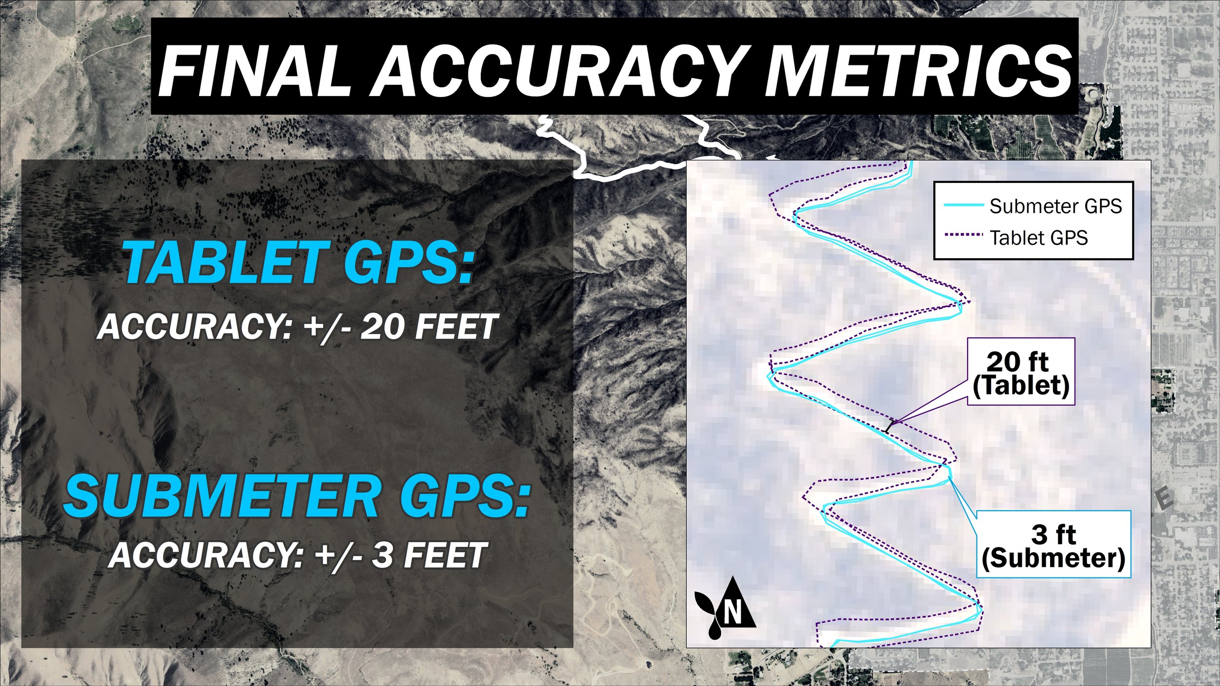
This disparity is a case study in why the tablet GPS can be a good tool for recording a general site location, while the submeter GPS excels at capturing the integrity of the details at a site. The Aspect team’s efforts demonstrated the importance of high quality tools for quality data—and high quality bike rides!
