

On December 3, Aspect’s Erik Pruneda, PE, CFM will be presenting on floodplain mapping changes due to climate change at The Seminar Group’s 18th Annual CLE Bootcamp in Seattle. His talk will focus on the impacts of climate change on coastal and riverine flooding and how flood hazards are being represented in the National Flood Insurance Program (NFIP) Floodplain Insurance Rate Maps (FIRM).
Wet weather season: When the levees go to work
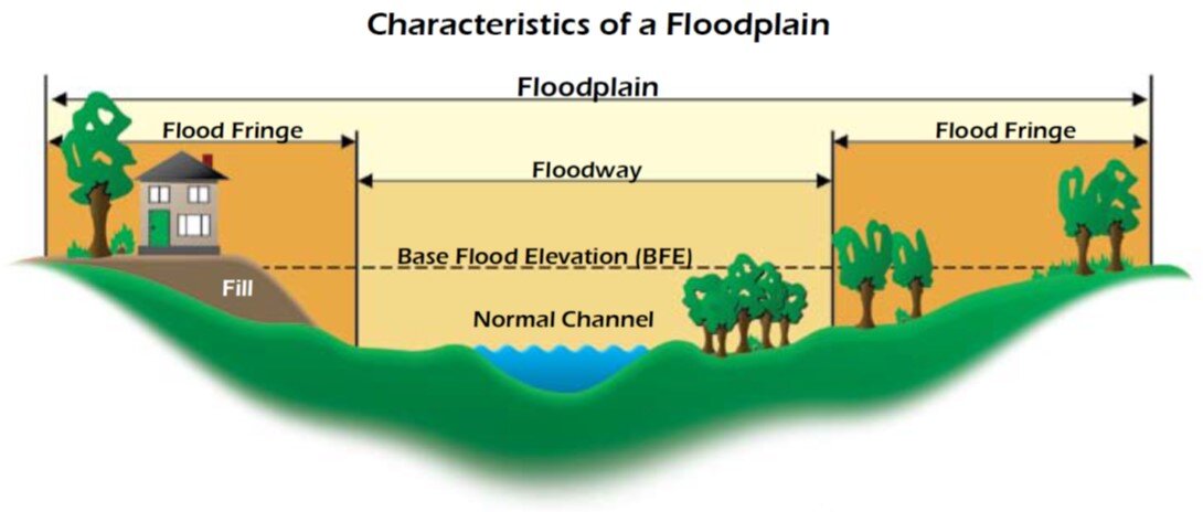
November is historically the wettest month of the year in western Washington. The seemingly constant mist of precipitation punctuated by storms that dump inches of rain in short amounts of time sends water levels in area rivers rising. The risk of flooding presents a critical need to protect nearby homes, businesses, and habitat. Levees a play a key role in that protection.
In the old days of flood control, a levee was typically little more than a pile of dirt. These days, they’re still dirt, but have evolved into a highly engineered, specifically designed mass, often made from less permeable soil (like clay) and designed wider at the base and narrower at the top. Levees are especially critical in floodplain areas to maintain healthy fish and riparian habitats, and of course near neighborhoods and businesses that would be vulnerable should a river top its banks.
While western Washington’s levees are working to protect their surrounding areas, Aspect is hard at work supporting several levee improvement projects in King County and beyond. Our services for recent and ongoing projects include:
Lower Russel Road Levee Setback, Kent, WA
Lower Russel Road Levee Setback, Kent, WA
Map from King County's Project Website
Lead geotechnical engineer and hydrogeologic support for Lower Russell Road Levee Setback, which is improving 1.4 miles of the flood control system along the Green River in Kent. Once completed, the project will provide greater flood protection and water conveyance capacity while improving both riparian habitat and recreational opportunities. This project is nearing the 60 percent design stage of completion, and is anticipated to be constructed by 2020. More project information and pictures can be found on King County’s project page.
South Unit Shillapoo and Buckmire Slough Restoration Design, Vancouver, WA
South Unit Shillapoo and Buckmire Slough Restoration Design, Vancouver, WA
Map from the Washington State Department of Fish and Wildlife’s project website
Geotechnical engineering and hydrogeologic efforts for the South Unit Shillapoo and Buckmire Slough Restoration Design, along the Columbia River in Vancouver, Washington. The project will improve hydrologic access to approximately 540 acres of intertidal, freshwater slough and wetland habitat. Our work first includes subsurface explorations and geotechnical design for breaching the existing levee (to clear room for the new levee); constructing three WSDOT bridges along State Route 501; flood control levee construction; roadway raises to meet 100-year flood elevations; and construction of up to 14 interior water control structures in the wetland system. You can read more about the project on the Washington Department of Fish & Wildlife’s website.
Countyline Levee Setback, Pacific, WA
Environmental and geotechnical support for the Countyline Levee Setback project along the White River near Pacific, just north of the border with Pierce County. When contaminated materials were encountered during construction of the Levee Setback project, our environmental team advised the County on whether the material posed a risk to the project if left in-place, while also determining proper disposal methods. Our geotechnical engineers conducted a targeted, cost-effective investigation to study flooding during high flows and collected data to inform the levee setback design. The project was finished this fall, just in time for late October rains, and now protects 121 acres of floodplain. See an aerial video of the project below
Pacific Right Bank Project, Pacific, WA
Pacific Right Bank Project, Pacific, WA
Map from King County’s project website
In late November, Aspect will provide both geotechnical and environmental services on the Pacific Right levee setback, along the opposite site of the White River from the Countyline Levee. The project will create a setback levee between the BNSF Railway and Government Canal to significantly reduce the potential for river flooding of adjacent neighborhoods. Learn more about the project on King County’s project website.
Habitat Restoration and the Geotechnical Engineer
Writing for the Daily Journal of Commerce, Aspect's Andrew Holmson covers why it pays to know your geotechnical engineer during habitat restoration work.
Making Room for Floods and Fish
As a recent sponsor of ASFPM (Association of State Floodplain Managers) national conference held in Seattle, Aspect had the opportunity to join 1200 national floodplain managers to learn about pilot improvements in flood risk management and national policy. The conference theme “Making Room for Floods and Fish” perfectly encapsulated floodplain management’s twin goals of habitat restoration/preservation and infrastructure rehabilitation/preservation.
Grounded in geotechnical principles, Aspect’s geotechnical practice specializes in floodplain management support and the associated infrastructure – such as culverts, roads, pipelines and bridges – that local flooding most impacts.