The Rainy Season Part 1: When Geohazard and Stormwater Specialists Shine

The end of 2019 and the first months of 2020 brought unprecedented rainfall across the Pacific Northwest—as just two examples, January was the third wettest Seattle month ever; areas in Northeast Oregon received 10 inches of rain in 3 days. This even-rainier-than-usual season has inundated the region with flooding and landslides. These events are a threat to the safety of homes, businesses, and infrastructure. In this two-part series, we’re highlighting how Aspect professionals have been helping assess earth and water challenges caused by the rain and help communities and clients problem-solve.

Our first part of the series looks at some of the scientific tools we use to track hazardous conditions during wet weather and how we respond to help local communities assess and repair damage from earth movement.

Landslides: When Water and Steep Slopes Don’t Mix

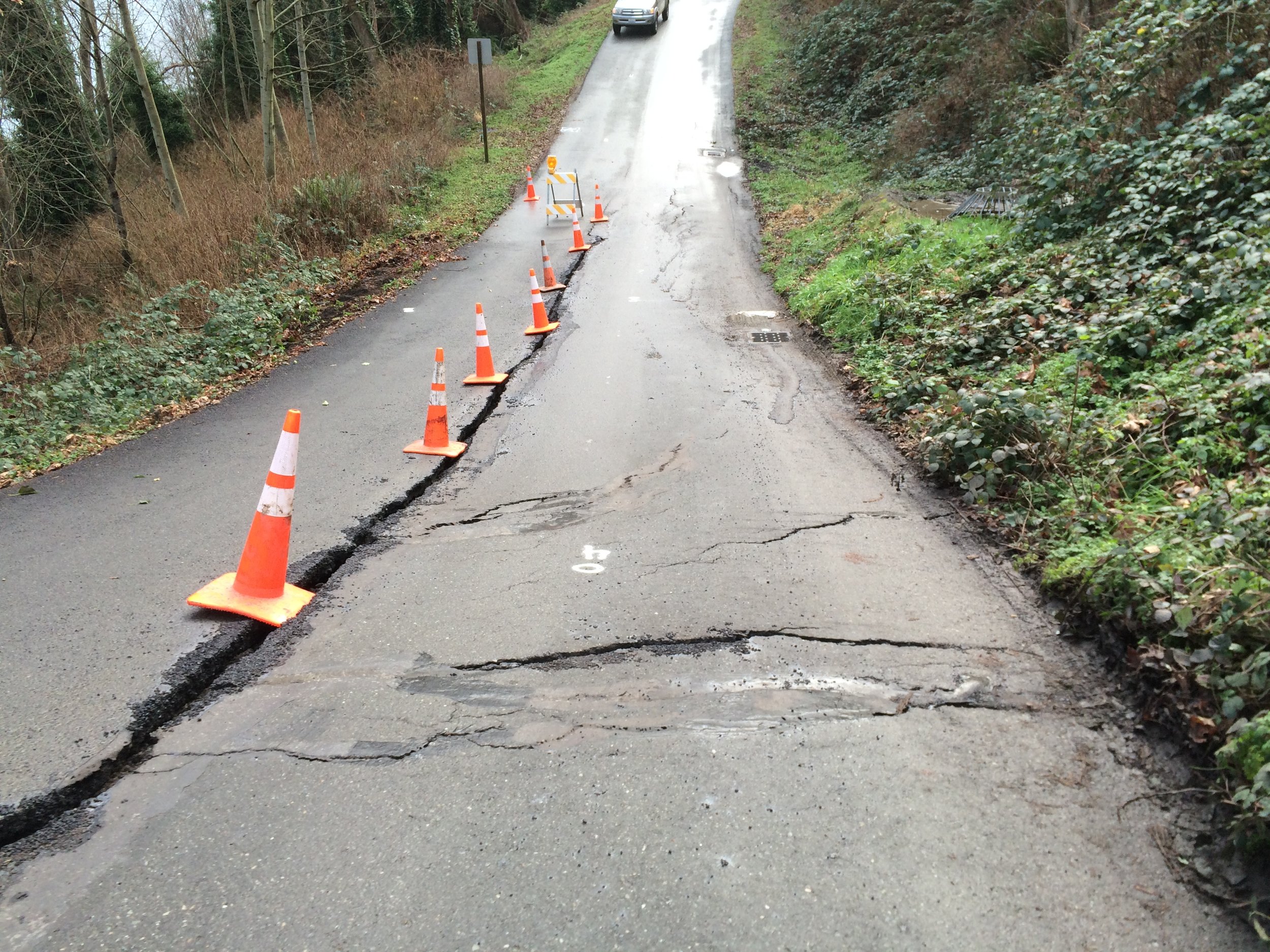
Landslides lie dormant and unseen to the untrained eye for years, and even decades. However, intense short-term or persistent long-term rainfall can waterlog steep slopes and awaken landslides triggering widespread damage. In February 2020, following a period of heavy precipitation, a landslide six miles south of Bellingham shut down half of Washington State’s main business artery – Interstate 5 – for half a day. 

Location of landslide across Interstate 5 south of Bellingham in February 2020

Photo Credit: Whatcom County Weather

One Tool to Understand Landslide Risk: Cumulative Precipitation Threshold 

Among other monitoring approaches, Aspect’s geohazard team uses a public tool created by the United States Geological Survey (USGS) to help continuously assess the level of landslide risk in the Puget Sound region.

This tool was developed after reviewing data on historical conditions from 1933 through 1997, including several notable intense rain events that triggered multiple landslides in the Puget Sound area—notably those in 1986 and 1997, which are two of the biggest landslide “years” in Seattle history because of the amount of rainfall (and for 1997, the rain fell on top of snow during the winter, creating significant soil saturation conditions).

The tool uses monitoring points near Puget Sound coastal bluffs to give a snapshot of rainfall intensity and duration in the area. From these data, the USGS developed “rainfall thresholds” to forecast landslide potential and risk along rail corridors between SeaTac and Everett.

From this data, the USGS developed an intensity (I) and duration (D) relationship (shown above).

For example, on the left side, the graph shows that 1/10th (0.1) of an inch of rain per hour, falling steadily for about 22 hours, is enough to enter the high-risk threshold (yellow area over the blue line). Similarly, about 1/20th (0.05) of an inch per hour falling over 45 hours will enter the threshold. This means short-intense rain AND less intense, but long-duration rainfall can both oversaturate the ground and cause a landslide.

How Wet Has Winter 2020 Been in the Pacific Northwest?

Thanks to recent data from the USGS’ Mukilteo monitoring station, Winter 2020 in the Seattle area has been a season of unrelenting precipitation. We’ve had two different periods where the Seattle area has been over the cumulative landslide threshold for two straight weeks.

This is a snapshot of Jan 29, 2020, landslide threshold graph. Any symbols to the right of (or above) the red line indicates heightened landslide risk. Taking about a 2-month period, from Dec 1, 2019 – Feb 11, 2020, the Seattle area has been to the right of the line twice for significant, extended periods of time (for about two weeks straight each time—Dec 20, 2019, through about January 7, 2020, and from January 28, 2020, through Feb 11, 2020.) Special thanks to Rex Baum of the USGS for the recent Seattle-area 2020 data.

That is a substantial amount of time for soils to stay wet because, well, water is heavy. And when water saturates soil over longer-than-normal periods it adds enough weight that can cause the soil to move on steep slopes. Think about the difference between a box of feathers on a sloped bed of marbles versus a box of wet feathers on that same sloped bed of marbles. The heavier that box becomes it starts to move. Here are some additional technical factors involved in this kind of landslide:

  • A buildup of groundwater can pressurize the soil’s pore spaces, which reduces the strength of the soils causing the soils to fracture or slide.

  • Trees and their root structures can greatly reinforce shallow soils, but they have less ability to hold onto soils that have lost strength due to saturation, leading to loss of strength in the soil reinforced layer and toppling of shallow, rooted trees.

Responding to Geohazards

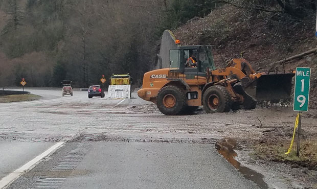
When active landslide hazard potential rises, Aspect’s geologists and geotechnical engineers prepare to support local agencies with whom we have on-call contracts. These contacts often include specific language that Aspect be ready to support public works staff as they respond to sudden or emergency geohazard events. During this last round of heavy precipitation, we were spurred to action with a call from the City of Kenmore—we provide geotechnical services as part of their team for an on-call contract—about a landslide impacting a roadway. We were on site to assess conditions within about one hour.

Result of a shallow surface landslide in Kenmore, which closed part of a road in the City.

Another view of the slide that resulted from heavy rains, which Aspect responded to within an hour.

The City wanted Aspect to assess potential risks. Are the residences atop the slope safe from further movement? How will removing the weight of the slide debris affect the slide? Our assessment concluded the slide posed a low risk to the residences and we were able to assure the City that removing the debris would not create further concerns for the slope.

Stay tuned for Part 2 of our Rainy Season series – where we learn how stormwater and water quality experts “storm chase” to track storms and perform water monitoring in wet conditions.

Seattle Area Hits Landslide Threshold

With the heavy rains late last week and this weekend, the Seattle area was pushed past the U.S. Geological Survey’s landslide threshold. Check the USGS website for current conditions and see how the rainfall intensity-duration threshold for landslides is calculated.

Additionally, this MyNorthwest article from 2017 provides an explanation of landslide risks in our region with tips on how to spot warning signs.

Reigning in the Looming Landslide in Kitsap County

As the Washington Boulevard landslide continues to move, it threatens to cut numerous Kingston residents off from the town and emergency responders.

Since a significant slide in 2006, Aspect has provided geotechnical services at Washington Boulevard, including gathering data and monitoring and studying movement along the slope. Recently, Kitsap County Public Works decided to implement a slope dewatering system to remove groundwater from the landslide mass and increase the stability of the hillside and roadway.

Aspect’s Andy Holmson provides some insight to the solution in this Kitsap Daily News article.

How Will We Hold Up to The Cascadia Megaquake?

Two recent articles in The Seattle Times explore how the Pacific Northwest's infrastructure will be affected by the next major earthquake.

New Cascadia quake analysis shows building retrofits could save many lives

How to survive the Cascadia Earthquake? Tips from seismologist Lucy Jones, ‘the Beyoncé of earthquakes’

Back in 2015, our very own Dave McCormack chimed in with his thoughts in response to the now infamous New Yorker story, The Really Big One

A Geologist's Thoughts on the Pacific Northwest Mega-Quake Story

Source: USGS

The Geology of Central Washington's Rattlesnake Ridge Landslide

Geology is on everyone’s mind in Yakima County as officials grapple with the ongoing Rattlesnake Ridge slide and how to help the community below it. This drone footage captures the surface features of the slide in detail. 

Given the geology of the area, Aspect’s Principal Engineering Geologist Dave McCormack summarizes the likely forces behind the slide: “Geologic studies have shown that slides of this nature are fairly common on the flanks of the numerous anticlinal ridges in central Washington. While most are ancient and have not moved during recent history, there are examples, including the Nile Valley landslide of 2009, where old slides have reactivated, or new slides began. These slides occur where basalt flows are interbedded with sedimentary strata. While the basalt strata may be relatively strong, the sedimentary interbeds are often weathered and weak.

When the gravitational driving forces acting on these dipping strata exceed the resisting strength of the weathered sedimentary strata, they begin to slide. There are multiple factors in the delicate balance of gravitational forces versus resisting strength, including the properties of the rock, degree of weathering, groundwater levels, the geometry of the slope, etc. 

Triggers for activation of landslides can include increases in groundwater level, strong earthquake shaking, or changes in slope geometry from natural causes like river migration, or human-caused grading. Because of the multiple factors involved, teasing out the exact triggers of a slope failure can be challenging, and the expected type of failure (fast debris runout, slow creeping failure, rockfalls, etc.) difficult to predict.” 

Geologic insight will continue to be relied on as the slide keeps moving.
 

Worldwide Great Shakeout: Are You Earthquake Prepared?

Stocked up? Emergency plan written and communicated? Even if you feel behind, just starting the process is a great first step.

Today is the Great Shakeout in the Pacific Northwest and worldwide.

See the resources below to get prepared in our “seismically rich” part of our world, including thoughts by Aspect’s very own geologic expert Dave McCormack on the science and potential of the Cascadia Subduction Zone i.e., the “Big One” occurring:

Great Shakeout Earthquake Drill

A Geologist’s Thoughtson the Pacific Northwest Mega Quake Story

Get Ready to Rumble: A Guide to Earthquake Preparedness by the Seattle Times

What Can I Do? Emergency Guide: From the City of Seattle's Emergency Management Guide

'Drunk Trees' and a Deluge of Rain Increase Landslide Risk

The Puget Sound area has been deluged with rain over the last few days, all within an already almost-record-breaking month of precipitation. With increased rain comes increased risk for landslides, and Aspect staff have responded to multiple ones over the last few days. This MyNorthwest article gives an explanation of landslide risks in our region with tips how to spot warning signs.

Aspect's Andrew Holmson Presenting at APWA's Fall Conference

Aspect’s Andrew Holmson will be presenting at the American Public Works Association’s (APWA) fall conference in Spokane on Thursday, October 6. He and City of Port Angeles Engineering Manager Kathryn Neal will present Protect and Innovate: Port Angeles Landfill Stabilization – the story of how the City and a large, multidisciplinary team relocated 400,000 cubic yards of refuse away from a 140-foot bluff overlooking the Strait of Juan de Fuca while building Washington’s tallest reinforced soil slope.

Aspect has provided geotechnical engineering, hydrogeology, and environmental support to the City’s closed landfill facility since 2007. We led the engineering geology team in determining long-term and short-term shoreline and bluff retreat rates, evaluating options for removal of existing shoreline protection structures, extending or modifying the structures, evaluating bluff slope failure mechanisms and slope stabilization options, landfill cell relocation, and fill slope stabilization and design. Work on the slope was completed ealier this year. Aspect continues to support the City with operation and maintenance of the landfill gas system and have provided environmental monitoring and support to meet regulatory reporting requirements.

Learn more about the APWA’s fall conference here and read more on Aspect’s efforts on the landfill here.