Aspect’s Nickerson and Berkompas Develop New Rain Garden Performance Tool

Aspect’s Curtis Nickerson and Bryan Berkompas recently developed a promising new, low-cost, telemetered rain garden performance tool – the Water Detector -- that can help cities and counties improve rain garden performance.

As more people move to western Washington and settle in its urban areas, stormwater runoff from streets, driveways, lawns, and rooftops is recognized as a major source of pollution impacting our waterways. To counter this continuing and growing threat, municipalities are encouraging broader public awareness and tools that public and business can use to clean polluted runoff as close to the source as possible. In this effort, rain gardens have become a major component of municipal stormwater management programs in western Washington.

Figure credit: www.12000raingardens.org

Rain gardens are a relatively low-cost natural filter and sponge, where runoff can infiltrate into the soil on-site rather than flowing directly into storm drains, streams or lakes.  Rain gardens are affordable to install, are an attractive landscaping feature, and are relatively easy for home owners to maintain. In Seattle, rain gardens and associated “Green Stormwater Infrastructure” (GSI) manage nearly 100 million gallons of polluted runoff annually.

While raingardens are seeing more and more adoption across Western Washington, measuring performance has been an area that has seen improvement. Typical methods – such as measuring flow rates--are costly and out-of-reach for typical municipal programs to widely adopt. To help resolve this data quality issue, Berkompas and Nickerson designed the Water Detector to give users a low-cost tool to see how well their rain gardens are performing.

The Water Detector is a low-cost, telemetered tool that measures a rain garden’s hydraulic performance.  

The target users for the Water Detector are municipal National Pollutant Discharge Elimination System (NPDES) permittees (cities and counties) in Western Washington and Non-Governmental Organization (NGO)s promoting the wide-scale use of Low Impact Development (LID) practices, including rain gardens.  Recently, all NPDES permittees in Western Washington revised their local development regulations to make LID methods, including rain gardens, “the preferred and commonly-used approach to site development.” Large investments by local governments for rain garden installations have already occurred and will continue to occur under the assumption that these facilities are working as intended. The Water Detector units could be deployed for a relatively low cost at hundreds of rain gardens across the region, providing real-world data to help assess the benefits of using rain gardens for decentralized stormwater flow-control on a broad-scale.

The initial target application for the Water Detector would be to assess a rain garden’s hydraulic performance. The single most important measure of rain garden performance, or lack of performance, is overflow or bypass, when excess runoff flows around or out of the rain garden instead of soaking into the soil. The Water Detector would be used to detect and record when and for how long the water level in a rain garden is at or above this bypass level. Data would then be uploaded automatically to cloud-based data storage via cellular or blue tooth technology. An additional potential application of this technology is monitoring bypass events at engineered stormwater treatment or detention systems to assess/alert when system maintenance is needed.  These data will help to assess and improve site evaluation and design methods, document long-term performance, and develop effective maintenance methods for rain gardens.

Prototypes have been developed, and Curtis and Bryan are currently identifying locations to test and deploy their Water Detectors. For more information, reach out to Curtis Nickerson (cnickerson@aspectconsulting.com) or Bryan Berkompas (bberkompas@aspectconsulting.com).

Groundwater Models: A Powerful Tool in the Hydrogeology Toolbelt

Meteorologists have them. Economists have them. And so do hydrogeologists. Complex computer models, backed by powerful processing power, help us understand and predict weather, wall street, and water. Indeed, groundwater models as predictive tools to forecast water movement and availability are a critical part of a hydrogeologist’s toolbelt.

Recently, Aspect hydrogeologists Seann McClure and Aaron Pruitt attended and presented posters at groundwater modeling’s premiere conference: MODFLOW and More, hosted in Golden, Colorado.

Seann (left) and Aaron (right) in front of their posters at MODFLOW and More

MODFLOW, the three-dimensional groundwater model developed by the USGS, is the industry standard for simulating and predicting groundwater conditions, and has been used to simulate everything from the impacts of climate change on groundwater/surface water interactions to the fate and transport of groundwater contamination to the intrusion of seawater into deep aquifers due to water supply developments. The conference is held every two years by the Colorado School of Mine’s Integrated Groundwater Modeling Center, and draws an international list of attendees from the consulting, academic, and government spheres to discuss all things MODFLOW and groundwater modeling.

Seann and Aaron each presented a poster describing Aspect groundwater modeling work. 

Applying Modelling Techniques to Evaluate Wetland Restoration Options Next to One of the Nation’s Busiest Airports

Seann’s poster presented on Aspect’s years-long work at Lora Lake wetland restoration, located adjacent to SeaTac Airport. The presentation, Groundwater Modeling to Support Wetland Restoration of a Former Peat Mine, discusses groundwater modeling completed to evaluate alternative cleanup scenarios at a former peat mine-turned-suburban lake located next to the SeaTac Airport’s new Third Runway. The lake has historically received stormwater discharge impacted by dioxin/furans and is being restored to a scrub-shrub wetland to remediate contaminated lake sediments through capping and filling in the lake. The groundwater modeling, sediment cap, and wetland restoration is part of a larger environmental remediation and construction effort led by Floyd|Snider on behalf of the Port of Seattle that also includes excavation of impacted sediments in the neighboring parcel.

Groundwater Modeling to Help Bolster Water Supply Resiliency for the City of Seattle

Aaron’s poster presented Aspect’s work on assisting a large Puget Sound public agency with predicting water supply availability in an urban area. The poster, Solving the Water Supply Puzzle: MODFLOW and Uncertainty in the Context of Mitigated Water Rights, focuses on the complexity of quantitative analysis necessary to satisfy permitting standards under Washington’s water rights regulations. Recent State Supreme Court decisions constrain mitigation options to those that meet a high bar of being “in-kind, in-place, and in-time”. This means any change to water levels or flows in a closed basin, no matter how small, is considered an impairment, and therefore grounds for rejection of a new water right. This stringent benchmark is even more difficult to deal with when it comes to using numerical groundwater flow models. Groundwater modeling requires simplifying assumptions about the system, which adds a layer of quantitative uncertainty on top of this already rigorous standard. In support of Seattle Public Utility’s effort to permit a future groundwater supply source as a component of resiliency planning, Aspect used MODFLOW to explore various water rights permitting strategies to determine the most defensible approach to in-time, in-place, and in-kind mitigation that balances water rights protections with the agency’s need for new water supply options. 

Controlled Atmosphere Storage: Keeping Northwest Fruit in Season Year-Round

In the Wenatchee Valley, it’s a common source of pride that Washington is the top producer of apples and pears in the nation. But with so much fruit coming off the trees at roughly the same time each year, have you ever wondered how crisp, crunchy apples and pears are available in the grocery store year-round? Or what enables people across the country—and around the globe—to recognize Washington as the source of the world’s best tree fruit varieties? Enter the technology of controlled atmosphere (CA) storage.

The Wenatchee Valley – the nation’s top apple and pear producer – keeps grocery aisles around the world stocked year-round by using massive, specially constructed warehouses designed to slow the ripening process.

A quick background on tree fruit: as apples and pears ripen, they take in oxygen and release carbon dioxide. Years ago, researchers determined that by limiting oxygen, introducing a little nitrogen, and lowering the temperature, the ripening process can be slowed. To apply this concept at a scale large enough to support Washington’s apple and pear industries, packers build enormous warehouses capable of holding multiple-orchards-worth of fruit within special airtight, refrigerated rooms. This gives shippers the flexibility to releasing fruit incrementally throughout the year, and allows you and I to enjoy a crunchy Honeycrisp apple in the middle of February, months after it was picked.

Building a CA-storage warehouse involves three special considerations: they must be massive, they must be stable, and they must be built quickly. Once fruit is off the trees, it gets hauled in bins that can weigh upwards of 900 pounds when full. Moving these bins requires big equipment (like forklifts and semi-trucks) and efficient storage requires stacking them up to 12 high—that’s a lot of weight! To maintain precise control of the atmosphere within these buildings, the rooms must remain airtight. This means that the foundation and walls must not shift, settle, or crack. Finally, market demands for additional storage capacity often drives the need for new CA warehouses to be built on short notice, with expedited timelines.

One full fruit bin can weigh 900 pounds. Stack those bins 12 feet high, and the need to engineer stable foundations for the warehouses that hold these bins becomes critical.

To meet these rigorous requirements, CA-storage warehouses are typically constructed out of giant precast concrete walls supported by cast-in-place concrete foundations capable of supporting substantial floor loads—up to 1,000 pounds per square foot. Designing for this type of stability requires the expertise of a geotechnical engineer for understanding how soils beneath the building will behave when loaded. By studying the local geology, excavating test pits, and drilling cores, geotechnical engineers can specify how wide and stout the footings and floor slabs should be at a given site.

Aspect geotechnical engineers Nick Szot and Erik Andersen have guided the design of several CA-storage warehouse projects for industry leaders like Blue Bird, Gebbers Farms, McDougall and Sons, and Peshastin Hi-Up. Aspect is proud to be the tree-fruit industry’s local, responsive firm for geotechnical services in the Wenatchee Valley and central Washington, and for our role in bringing Northwest pride to homes across America and around the world. 

When Science Meets Bike to Work Month

With May just wrapped up, Aspect's annual participation in Bike to Work Month is in the books! This year, 40 Aspect employees participated in the Washington Bikes Bike Everywhere Challenge. All month long, we logged our bike rides and commuting mileage to and from our offices in Bainbridge Island, Bellingham, Portland, Seattle, Wenatchee, and Yakima to compete with other Washington Architecture and Engineering firms for the coveted 2017 A&E Bike to Work Month trophy. 

The highly coveted (depending on who’s asking) Golden Helmet that Aspect won in the A&E section of the 2016 Bike-to-Work challenge.

For some Aspect-ians, it isn’t enough to just ride bikes around to compete for a prize. Bike to Work Month presents the perfect opportunity to strap some expensive field gear to our bikes and mix a little science into our weekend rides. On a recent weekend, an Aspect team set out to do just this by testing two different GPS mapping devices along trails in the beautiful Chelan-Douglas Land Trust in the Wenatchee Valley.

It's IPAD Mini vs. Trimble GPS in a mapmaking showdown on the sunny trails of the Chelan-Douglas Land Trust in the Wenatchee Valley.

Watch the video for a firsthand look at the trail ride.

Accuracy is at the heart of our Data and Mapping studio group. Some mapping devices are more accurate than others. A little extra effort selecting the right piece of gear before rolling out to a site visit can lead to the creation of a better dataset to help get the job done. The difference in GPS device accuracy can be hard to appreciate by reading raw numbers from a manufacturer’s specifications, but a visual presentation can drive the message home and show how your data can be improved by selecting the right device.

To demonstrate the importance of using the right tool for the job, a senior GIS analyst and her loyal canine sidekick chose to ride a loop of the Sage Hills trail system to put two common tools of the trade to the test – the Apple iPad Mini (tablet GPS) and the Trimble R1 submeter (submeter GPS).

Apple iPad Mini (left) and the Trimble R1 Submeter (right)

After their ride, the team dropped by Aspect’s Wenatchee office and crunched the data, mapping out the trails tracked by both the tablet GPS and the submeter GPS. While the calculated overall ride length varied by only a few percentage points between the two devices, a close inspection of the data revealed dramatic variation in the projection of the trail lines over an aerial image. As shown in the photos below, the path tracked by the tablet GPS typically deviated +/- 16 feet away from the trail mapped by the submeter GPS and contradicted the trail lines visible in the overlaid aerial photos.

 This disparity is a case study in why the tablet GPS can be a good tool for recording a general site location, while the submeter GPS excels at capturing the integrity of the details at a site. The Aspect team’s efforts demonstrated the importance of high quality tools for quality data—and high quality bike rides!

300 Spokane Residents Turn Out to Hear About Hirst Water Rights Decision

Aspect’s Dan Haller and Carl Einberger helped Spokane County (County) officials present on the relevance of the "Hirst" Decision to a packed public meeting on May 19th. Over 300 local residents showed up to hear the County and Aspect go over:

  • The context that led up to the Hirst decision, including some understanding of the evolving interpretations of Washington State water rights law;
  • The role of watershed planning and hydrogeology studies in the Little Spokane basin;
  • Why the County has been proactively planning to implement a water bank; and
  • How a water bank works.

As counties across the state continue to grapple with the implications of Hirst and what it means for property owners and developers in rural areas, Aspect expects public outreach efforts to continue to help guide the conversation over this evolving topic and legislation.

Aspect Stormwater Team Presents at MuniCon 2017

Aspect is proudly sponsoring and presenting at this year’s Washington State Municipal Stormwater Conference (MuniCon), May 16 & 17 in Yakima, WA.

On Day 1, Senior Associate Engineer, Tom Atkins and Senior Project Hydrogeologist, Andrew Austreng will be leading a discussion on infiltration testing requirements from the Stormwater Management Manual for Western Washington.

During Day 2, Senior Hydrologist, James Packman and Greg Vigoren, City of Lakewood, will be presenting an evaluation of Western Washington Illicit Discharge Detection and Elimination (IDDE) data. Later in the day, Principal Engineer, John Knutson and Project Engineer, Erik Pruneda, along with Rob Buchert, City of Pullman, will be presenting on designing and constructing Low Impact Development (LID) retrofits in low permeability soils.

Aspect’s Tom Atkins and Senior Hydrologist, Bryan Berkompas will also be displaying poster presentations. Tom will be providing a poster on assessing the feasibility of stormwater infiltration at the Seattle-Tacoma International Airport. While Bryan’s poster demonstrates a hydrologic performance evaluation of ten bioretention facilities across the Puget Sound region through a project funded by Stormwater Action Monitoring.

The conference is presented by the Washington Stormwater Center, in partnership with Yakima County and the Department of Ecology. This unique conference focuses specifically on addressing high-priority issues and challenges faced by municipal NPDES permittees statewide. Learn more about the conference at: http://www.wastormwatercenter.org/municon2017/.  

Aspect Honored to Be Part of Several APWA Projects of the Year

Aspect was honored to be involved with several projects that won top honors at the 2017 APWA-WA Conference in Tacoma, Washington.

In the Structures category, Kitsap County Public Works’ Bucklin Hill Bridge and Estuary Enhancement won Project of the Year in Washington State as well as a National award from the APWA. The City of Wenatchee’s 2016 Pedestrian Safety Improvements project also won Project of the Year in the Environment category.

See Kitsap County's time-lapse construction footage below.

The Bucklin Hill Bridge/Estuary Project rehabilitated the Clear Creek estuary to allow for smoother fish passage and also widened the road to reduce traffic congestion. Working with the OTAK-led project team from 2010-2016, Aspect performed the geotechnical work to replace the 72-inch-diameter culverts with a four-lane bridge.

For the Wenatchee Pedestrian Safety Improvements project, Aspect worked with the City of Wenatchee and WSDOT to collect and review the logs of subsurface explorations previously completed near the project area for other studies.  Using this data allowed the City to save money by forgoing additional explorations and Aspect to develop geotechnical recommendations to support design and construction of a large cantilevered signal pole for pedestrian crossings.

Chris Augustine Presents on Key Concepts in Thermal ASR Systems at AWWA

Aspect’s Senior Hydrogeologist Chris Augustine will be presenting on his work on developing a thermal Aquifer Storage and Recovery (ASR) system at this year’s annual Pacific Northwest Section American Water Works Association (AWWA) conference in Kennewick, WA.

While at another firm, and collaborating with Boise White Paper, LLC (Boise) and the Washington Department of Ecology (Ecology), Chris worked on a Wallula, Washington project that would store cold Columbia River water in the winter and spring months and then recover the stored water during the summer months when the temperature of the Columbia River becomes warmer. 

His presentation will focus on the goal of the project to reduce operational costs for cooling of process water and reduce surface water diversion during the summer to meet the target yield of 4,000 gallons per minute.

Learn more here: American Water Works Association

You can get there from here: Ending post-closure activities at old landfills

After landfills stop accepting waste, they transition into a post-closure period of typically 30 years or more. Towards the end of the post-closure period, landfill managers try to terminate or modify monitoring requirements in compliance with criteria and regulations.  Data collected on settlement, leachate generation, groundwater quality and landfill gas production are evaluated to demonstrate if monitoring activities can be terminated or reduced.

In one example of successful post-closure transition, see Seattle’s South Park Landfill before (2007) and after (2016) closure. The landfill was capped and redeveloped as a parking and storage facility.

On April 26 at the 2017 NW Regional SWANA (Solid Waste Association of North America) Conference in Tulalip, Aspect’s Peter Bannister will discuss his experience at closed landfills in eastern and western Washington and lessons learned that have set these sites up for terminating or reducing post-closure activities with regulatory certainty.

Learn more and register here.

Competition and Opportunity: Panel on Affordable Housing and Contaminated Sites in Puget Sound

Just like everyone else in today's real estate market, Puget Sound housing authorities, non-profits, and entities are looking for property in a region that has become very expensive. That has resulted in stiff competition from all purchasers – private and non-profit --for developing even contaminated sites, which only adds to the already high cost of development. Into this mix, money for affordable housing is tighter and lending requirements more conservative. Conversely, outside the Puget Sound region, contamination commonly puts property values under water, leaving key land underutilized.
 
However, affordable housing success stories are happening and showing that buying and redeveloping a brownfield property can lead to homes; more productive use; a cleaner environment; jobs; and retail.  On April 20 in SeaTac, Aspect’s Dave Cook and Jessica Smith join Ken Lederman and Jacquie Quarré of Foster Pepper PLLC for a panel discussion hosted by the Association of Washington Housing Authorities (AWHA). The group will cover the potential of brownfields sites for Housing Authority entities from the regulatory, legal, and environmental perspectives and present several recent affordable housing development stories, including Rainer Court and the Mt. Baker Housing Association.  
 
Learn more about AWHA here.

It’s a Wrap on the Cap: Port of Bellingham completes major cleanup milestone to redevelop Bellingham’s Waterfront District


A video history of the past, present, and future of the transformative Bellingham waterfront redevelopment.

Along the east side of the Whatcom Waterway in Bellingham, a layer of gray gravel stretches over the landscape. This “cap” of crushed rock and surrounding paved surfaces is a culmination of years of efforts to clean up soil and groundwater on the grounds of a former pulp and paper mill. Completion of the capping clears one major hurdle for the Port and City of Bellingham to create a new, vibrant waterfront.

Video Credit: Port of Bellingham

A historically industrial site with strong post-cleanup potential

The waterfront has always been central to Bellingham’s industrial past. Where the cap sits now was originally tideflats that were filled to create new upland for industrial use: salmon canning operations in the early 1900s, giving way to a pulp mill in the 1920s. In 2005, Georgia-Pacific (GP) sold 137 acres of land, including the 64-acre mill property, to the Port of Bellingham, and GP’s last mill operations closed in 2007. Despite the contamination that resulted from the industrial activities, the Port and the City did not give up on this property and saw the cornerstone of a new Bellingham waterfront—it only needed remediation to set the stage for productive and safe reuse.

How to Clean It Up

Heavy industrial use left some contamination in soil and groundwater across the majority of the mill property, which, for purposes of the environmental cleanup, is termed the GP West site. In 2009, the Port and the Washington State Department of Ecology (Ecology) executed an Agreed Order to investigate and determine the appropriate “cleanup action” for the site. First, Aspect completed a Remedial Investigation to document the soil and groundwater across the entire site. While the investigation was underway, the Port and Ecology agreed to proactively undertake interim cleanup actions to permanently remove areas of high-risk soil contamination (Bunker C fuel oil and liquid mercury) while working to create the cleanup plan for the larger site.

In 2013, the Agreed Order was amended to divide the GP West site into a pair of Remedial Action Units (RAUs): the Chlor-Alkali RAU that encompasses mercury contamination from a former mercury-cell Chlorine Plant on the south end of the site; and the Pulp and Tissue Mill RAU that encompasses the former pulp mill and tissue mill areas to the north. Ecology agreed to do this to expedite cleanup and facilitate redevelopment, recognizing that cleanup of the Pulp and Tissue Mill RAU was less complicated and could be accomplished more quickly than could the Chlor-Alkali RAU. In 2014, a Cleanup Action Plan (CAP) specified the final cleanup action for the Pulp and Tissue Mill RAU. The final cleanup for that RAU involves additional removal of contaminated soil, and, in a few areas, monitoring the natural restoration of groundwater.

What it takes to put a Cap on 31 Acres

A major challenge for the capping project was achieving a protective barrier across 31 acres of highly variable surface conditions remaining after demolition of the former mill, while also maintaining accessibility and stormwater drainage until redevelopment reconstructs the area. The surface that required capping was a mish-mash of material types and grades: pavements of variable type and condition, intact concrete slabs of all dimensions and heights, crushed concrete and brick, and a hill of soil that historically served as a street onramp. Further complicating the effort was a widespread surficial layer of dirt and rocks presumed to have contamination from historical activities, termed “veneer.”

Aspect was involved throughout the capping project, from conceptual design to the construction plans and specs and bid process, and then overseeing work to ensure it was done to the CAP specifications. The capping itself took about 90 days, as outlined in these photographs:

Before – Pre-existing site surfaces requiring capping

Random intact slab with "veneer" around it.

Crushed concrete from mill demolition.  Also note that the Port saved some buildings and structures, like the “acid ball” and the “pulp digester” towers shown here, to contribute to the aesthetics of the planned redevelopment.

The hill of soil that historically served as a street onramp.

During – Regrading and consolidating contaminated material 

The initial steps of the capping project included grading off the tops of the soil knolls to match surrounding grades, as well as removing the “veneer.” The latter was done with excavators, street sweepers, and even a good old-fashioned broom in some areas. All of the excavated and swept-up contaminated materials were consolidated as fill to raise grade in a low area just south of the knolls.

During – Smoothing it out

Next, the site needed to be evened out. The contaminated soil fill was graded and compacted to a flat surface. Because it was to be capped with clean imported soil, a bright orange geotextile was placed across the contaminated soil subgrade to provide visual notification for potential future excavation through the cap during redevelopment. Adjacent stockpiles of crushed concrete and brick from prior building demolition were likewise leveled and compacted – creating a firm, flat subgrade across the entire fill area.

During – Capping it off

Once the fill was consolidated and evened out, the entire 31 acres needed to be capped. The cleanup plan called for a minimum of either 3 inches of competent hard surface (asphalt or concrete pavements or foundations), or 2 feet of clean import soil/rock, overlying the contaminated soil. Ultimately, contaminated soil was capped with 2 feet of import material (6 inches of crushed rock over 18 inches of sand and gravel) on top of the orange geotextile, while the cap across the rest of the area was a combination of pre-existing competent hard surfaces and new asphalt pavements. The capping also cleaned out and secured more than 170 vaults and other subsurface structures to eliminate physical hazards to foot and vehicle traffic and to control stormwater drainage.

Done – The finished product

The finished cap will keep people from coming into direct contact with potentially contaminated soil. The project also improved stormwater drainage, and provided an overall upgrade to the site’s aesthetic. Aspect will also continue to monitor the groundwater on the site as the Port and City plan their next steps.

What’s Next: Reconnecting the Community to the Waterfront

Just as the waterfront has been central to Bellingham’s past, it is now the key to its future. With the cap in place, the potential of this prime waterfront area is just now being unlocked. The old Granary building at the corner of the cleanup site is undergoing renovations to house shops and restaurants. The City is planning for construction later this year of the first arterials and utilities, as well as a park that will allow the community to directly access the waterfront. And rather than forget the past use of the area, the City has embraced it with a public competition to reimagine the site’s “acid ball” as an art installation within the new park.

How Dirty is the Dirt: Ripple Effects of Proposed Solid Waste Handling Regulations

The difference between “clean” and “dirty” dirt may become a lot more complex if new solid waste handling regulations take effect in Washington state. The state’s Department of Ecology (Ecology) has proposed significant revisions to Washington Administrative Code (WAC) Chapter 173-350, which governs how solid waste is managed. The proposed changes, which will be formally proposed later this year, will affect a number of solid waste practices, but the key revisions with the most significant implications concern creation of a new section establishing and standardizing criteria for managing the movement, reuse and disposal of soil and sediment  that is considered “clean” under the state’s Model Toxics Control Act (MTCA) but may have trace levels of contaminants (draft WAC 173-350-995).

Excavated soil from Seattle City Light’s new Denny Substation in South Lake Union. Under proposed new solid waste regulations, managing, hauling, and receiving this soil will likely be much more complicated for engineers, redevelopment teams, and landfill operators.

With the Puget Sound region by some counts leading the nation in development projects – which all generate dirt during construction excavation that must be reused or hauled away – establishing soil management protocols will likely have significant ripple effects in the business and regulated community. Consider just one urban skyrise, as this article on construction dirt does. A typical downtown Seattle building project could potentially generate 250,000 cubic yards of soil (equal to 25,000 dump truck loads) that must be removed from the site. The new soil and sediment criteria would potentially mean higher sampling costs, more complex soil management plans, additional reuse constraints, and greater soil volumes filling up limited landfill space.

How managing “Dirty” Dirt would change

Contaminated sites are regulated under MTCA, which provides screening criteria for defining impacted soil. Soil with contaminants below MTCA screening levels is considered “clean”. Currently, the end use of “clean” excavated soil is largely determined by criteria set by individual receiving facilities—gravel mine, landfill, reuse site, etc. These facilities may all have different standards for what level of impacted soil they will accept. The new proposed regulation would change that, formulating the screening process for “clean” soil and creating formal soil reuse and disposal acceptance criteria. This means that “clean” soil (albeit with low levels of contaminants at concentrations protective of human health and the environment) would now need to go through rigorous sampling, laboratory analysis, evaluation, and jurisdictional health department permitting just to be hauled away. This would be a big change from the current process, where this same “clean” soil can be reused as fill because it is deemed “protective” of human health and the environment, per MTCA.

Implications of new regulations

At the heart of the update is the intent to formally regulate soils that are not perfectly clean. Ecology hopes the rule update will streamline management, decrease delays in soil movement, reduce the potential for creating new cleanup sites, and reduce environmental damage. Practitioners see the implications of these proposed rule updates as increasing the cost of development projects, slowing development schedules, creating a regulatory quagmire, and causing landfills to fill with soil that could be put to use elsewhere.  

Helping Bring Clean Water To Guatemala

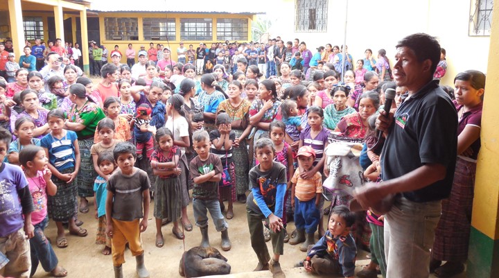
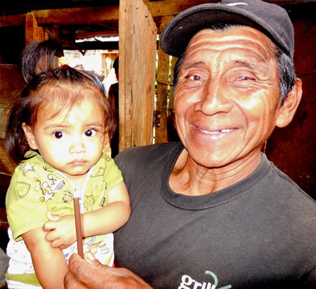
In 1985 a US doctor and his wife traveled to the Northwest highland area of Guatemala, where they observed areas of extreme poverty and little infrastructure. Dr. Leeon Aller, MD and his wife Virginia soon decided to dedicate themselves to helping this region and in 1991 established Hands for Peacemaking Foundation (HFPF), based in Everett, Washington. Going strong in 2017, the Foundation provides infrastructure and other support services to over 250 villages in this mountainous area, where running water and electricity are the exception and having clean drinking water can be a daily struggle for villagers. 

For many years, Aspect has been supporting HFPF efforts to help some of the area villages solve water supply challenges and also provide geological assistance with the landslide-prone environment these mountain villages exist in.

 The Water Story of San Francisco JolomtaJ

Located 10 miles from the nearest town of Barillas, San Francisco Jolomtaj is home to 160 families and does not have electricity or running water.  For drinking water, the villagers have a choice -- they can build wooden boxes like that pictured below or walk to a spring to get and carry back water (this can mean a 4-5 hour round trip trek).

Existing wooden box water supply for the village

Villagers trekking back up the mountain with water from the spring

To help this situation, Aspect and others are funding construction of rooftop rainwater collection system for the community school and individual families—primarily widows and the elderly who struggle to get water for themselves. 

San Francisco villagers loading supplies to build the tank system

Family and finished water tank

HFPF partners with the villagers to build the water systems. These systems don’t replace the spring sources, but they do provide critical water emergency supply and are filtered to block contaminants. The work in San Francisco is currently ongoing, with additional collector and tank systems constructed as funding allows.  You can learn more about this project and other humanitarian projects by visiting the  Hands for Peacemaking Foundations website.

Kittitas County: Leading the Charge on Water Banking

On April 12, Aspect’s Dan Haller will co-present with Kittitas County Commissioner Paul Jewell on the future of Kittitas County Water Resource Management. Kittitas County has been at the heart of the state’s recent water banking approach with the most mature and heralded water bank in Washington. Over the past 10 years, they went from the staunchest opponent to exempt well management to the unquestioned leader in the State, with broad state, local, and tribal endorsement of their transformation.

Over the years, Aspect has helped the County develop the program, including an innovative "over the counter" water rights program.

The presentation will be at the Starlight Lounge in Ellensburg and hosted by the Washington Chapter of the American Water Resources Association (AWRA).

For more details and to register click here.

Aspect Helps Kittitas County Offer 'Over-the-Counter' Water Rights

Aspect has been assisting Kittitas County with implementation of their water bank. The newest feature is a general permit that allows the County to cover non-exempt uses in a streamlined manner through issuance of mitigation certificates, similar to their over-the-counter approach for exempt well mitigation.  This allows property owners to continue to interface in a streamlined and coordinated manner with Kittitas County instead of seeking one-on-one solutions with Ecology, that would be more time-consuming and expensive.  This is another example of how Aspect continues to assist counties with innovative solutions to Hirst-related issues

Check out this article by The Daily Record News for more detail!

Aspect Paves the Way for a First-of-its-Kind Affordable Housing Project

Five pieces of land in southeast Seattle’s Mount Baker neighborhood have sat unused for years. Contamination from a former gas station and dry cleaner has plagued the area’s potential, especially since they sit just two blocks away from the Mount Baker light rail station. However, that’s all changing thanks to an innovative collaboration between the Mt. Baker Housing Association, the City of Seattle, and the Washington State Department of Ecology.

Click image for King 5's video on the Mt. Baker Gateway Project

With the creation of a Redevelopment Opportunity Zone (ROZ), 150 units of affordable housing will soon go up in one of the City’s most racially and ethnically diverse neighborhoods. This ROZ designation—the first-of-its-kind in the state—allows for state money to be used for the environmental cleanup. With this innovative model, these previously undevelopable parcels are on their way to becoming crucially needed affordable housing.

Aspect's Jessica Smith and Dave Cook at the site of the Mt. Baker Gateway project.

Aspect has been leading the environmental strategy with Mt. Baker Housing’s legal advisor, Seattle law firm, Perkins Coie. Like any complex urban brownfield project, progress requires a unique strategy, buy-in of stakeholders, and a demonstration of a win-win. The environmental cleanup consulting that Aspect is providing will set the stage for remedial cleanup of petroleum and solvent-contaminated soil and groundwater. The cleanup action will do more than benefit the parcels, it will improve environmental quality of this part of the neighborhood. Groundbreaking is estimated for 2019.

Look out for future project updates and milestones as we play our part in realizing the vision of this community and stakeholders for affordable, sustainable, and healthy housing in Seattle.

Aspect Honored with ACEC Award for Port Angeles Landfill Project

The American Council of Engineering Companies (ACEC) honored Aspect’s Port Angeles Landfill Stabilization Project in both Washington and Oregon at the organizations’ annual Engineering Excellence Awards.

The Port Angeles Mechanically Stabilized Earth (MSE) Slope Stabilization received a Grand award at the ACEC Oregon’s awards program in Portland, with Aspect’s Pete Stroud and Mark Swank in attendance. ACEC Washington recognized the project as a whole with a Silver Award for Social Economic and Sustainable Design Considerations at its Awards Gala in Bellevue.

Aspect was part of a large multidisciplinary team supporting the City of Port Angeles with environmental and geotechnical services on the $17 million project that moved 400,000 cubic yards of refuse away from a 140-foot bluff overlooking the Strait of Juan de Fuca while building Washington’s tallest reinforced soil slope. Slope construction was completed in 2016, and we will continue support with groundwater quality and seawall fluid reporting, landfill gas system evaluation/optimization, and monitoring of the MSE slope and landfill cover.

Aspect also played a role in several other projects honored by ACEC Washington. We served as lead geotechnical engineer on the Lodge Creek Culvert Replacement for Kittitas County, which received the Silver Award for Successful Fulfillment of Client/Owner Needs. The University Link Extension, which Aspect led the design team on exploration, engineering geology, and hydrogeology to build Sound Transit’s light rail tunnel from Capitol Hill to the University of Washington, received a Gold Award for Transportation. We also were the lead geotechnical engineer on two Best in State Bronze Award-winning projects: NW Bucklin Hill Bridge & Estuary Enhancement in Kitsap County and the Dungeness River Railroad Trestle Replacement for the Jamestown S’Klallam Tribe.

The Seattle and Oregon editions of the Daily Journal of Commerce have an overview of this year’s AECE Washington and ACEC Oregon winners. 

Curtis Nickerson Presenting on Stormwater Monitoring Tips and Trip-Ups at Oregon ACEC

Aspect’s Senior Associate Environmental Scientist Curtis Nickerson will be presenting at Oregon’s ACEC Environmental Water Resources Group (EWRG) on January 25 at the Hawthorne Lucky Lab Brew Pub in Portland. Curtis will talk about lessons learned in his 20 years of chasing storms. He will pass along tips for anticipating trips-ups during sampling and discuss monitoring site selection; innovative instrumentation and methods for monitoring at difficult locations; field procedures and QA/QC activities for flow metering; and water sampling and sediment monitoring.

Know Your Source: Exploring Hydrogeology’s Role in Water Rights Transfers

Check out the January issue of The Water Report, where Aspect’s Associate Hydrogeologist Tyson Carlson explains the key role hydrogeologic evaluation plays in successful water rights transfers. The article revolves around the “same source” concept and how understanding the hydrogeologic system of a site will help you manage risk, expand transfer options, and bring more certainty to regulatory approval.

Read the article here.

This article is reprinted with permission from The Water Report. A review copy of The Water Report is available to anyone, upon request, at www.thewaterreport.com.

Examples of Same Source Part of a Common Flow Regime

Meet Na Hyung Choi and Allan Covell

Aspect is excited to welcome Na Hyung Choi and Allan Covell! Staff Geologist Na Hyung recently completed her MS in Geology at Oregon State University. Her graduate work focused on geomorphology and structural geology of faulted alluvial fan complexes through field assessments, remote sensing, and numerical modeling.  She joins Aspect's Bainbridge office, where she has been busy with steep slope reconnaissance and subsurface investigations for our geotechnical group. Alan joins Aspect's Yakima office as an engineering designer. Allan brings over 15 years of experience as an engineering drafter/designer and will be engaged in water resources, geotechnical, and environmental projects at Aspect. Here are five questions we asked to get to know them better.

Na Hyung Choi

1.    Where are you from? If you’re not from the Pacific Northwest, what brought you here? 
I was born in Seoul, South Korea, and spent my childhood there, but I did most of my schooling in Georgia (the state). Then I moved to Corvallis, Oregon, for graduate school and lived there for 3 years before moving to Washington to join Aspect.

2.    What inspired you to pursue geology? What made you curious about it? 
I am a little bit surprised how things turned out. I remember from middle school the disdain I felt toward my younger brother’s mineral collection because it seemed so nerdy! But gradually I became aware of my appreciation for the outdoors and my enjoyment for learning why things look and act like they do. When I learned that a geology degree at the University of Georgia required a 6-week field course in Colorado, I was sold. Also, being in the South, I liked how I could delve into topics like evolution, climate change, and resource exploration that many found/find controversial. 

3.    What do you like best about your area of expertise? What excites you and keeps you motivated? 
I like being able to picture the processes that formed a landscape when I look around, and I can’t imagine exploring the world any other way now. At work, I enjoy applying my geological background to urgent questions by putting my foot on the ground and probing what’s around and underneath. I like seeing concrete reasons and results of my work, and it’s exciting to be able to say, “Hey, I helped build that!” or “Hey, I helped make this house a safer place to live!” I thrive when I’m constantly learning new things, and I’m very happy to be doing just that every day at Aspect.

4.    What do you like to do when you aren’t working? 
I love to cook. I read cookbooks for fun, watch a lot of cooking videos, and sometimes fantasize about taking a week off just to try a bunch of recipes. I love being in the mountains and try to go hiking every weekend. I also enjoy trying to rock climb, playing violin, visiting the local animal shelter to pet cats (and dogs), and goofing off with my partner, Phillip.

5.    Where in the world would you like to travel next? 
I’ve been wanting to visit Japan for a long time, largely for their food.


Allan Covell

1.    Where are you from? If you’re not from the Pacific Northwest, what brought you here? 
I’m born and raised in the Yakima Valley, currently living in Selah. I’ve lived in the Tri-Cities, Ellensburg, Spokane, and Puyallup, but have always felt more at home in Yakima area. I like being near the mountains and sagebrush, surrounded by all the orchards, vineyards, and hops. It makes all the seasons very distinct and beautiful.

2.    What inspired you to pursue Engineering? What made you curious about it? 
My father is a Civil Engineer, so I was exposed to his type of work from an early age. He would take me to his office and various construction projects that he was working on. I was curious about it because I like to know how things were designed and built. I especially liked looking at drawings and maps.

3.    What do you like best about your area of expertise? What excites you and keeps you motivated?
I
’ve always liked drawing, and CAD software means I can do it faster and better than I used to by hand way back in high school and at my first job. Since Autodesk has been improving Civil3D, drawing cool things in 3D has gotten a lot easier and more accurate. I’m excited to see where this software is headed over the next few years.

4.    What do you like to do when you aren’t working?
I enjoy spending time with my family, especially watching my kids learn and play sports. I also do some running (road and trail) when I have time and play coed volleyball on a city league team.

5.    Where in the world would you like to travel next? 
I’d love to go back to Cancun, Mexico for a second honeymoon. It’s been over 15 years since I was there and I’d like to see if my memory matches reality. Plus, I’d love to bring my kids along so they can experience a foreign country (Canada doesn’t count), some high humidity heat, and gorgeous white sand beaches.